A sharp deterioration of the weather is expected, with the main feature being a drop in temperature.
According to meteorologists, polar air masses from the Balkans will cover the country starting from Wednesday (19/2), bringing a sharp drop in the mercury by up to 10 degrees and snowfalls.
Meteo: Gradual temperature drop and snow starting today (19/02)
The drop will initially be felt in central and northern mainland Greece, where temperatures are not expected to exceed 5 to 7 °C.
At the same time, rain showers will occur today mainly in Thessaly, Eastern Central Greece, Eastern Peloponnese, the Cyclades, and Crete.
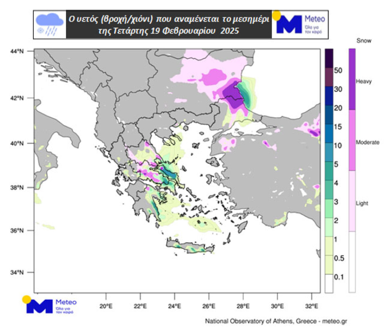
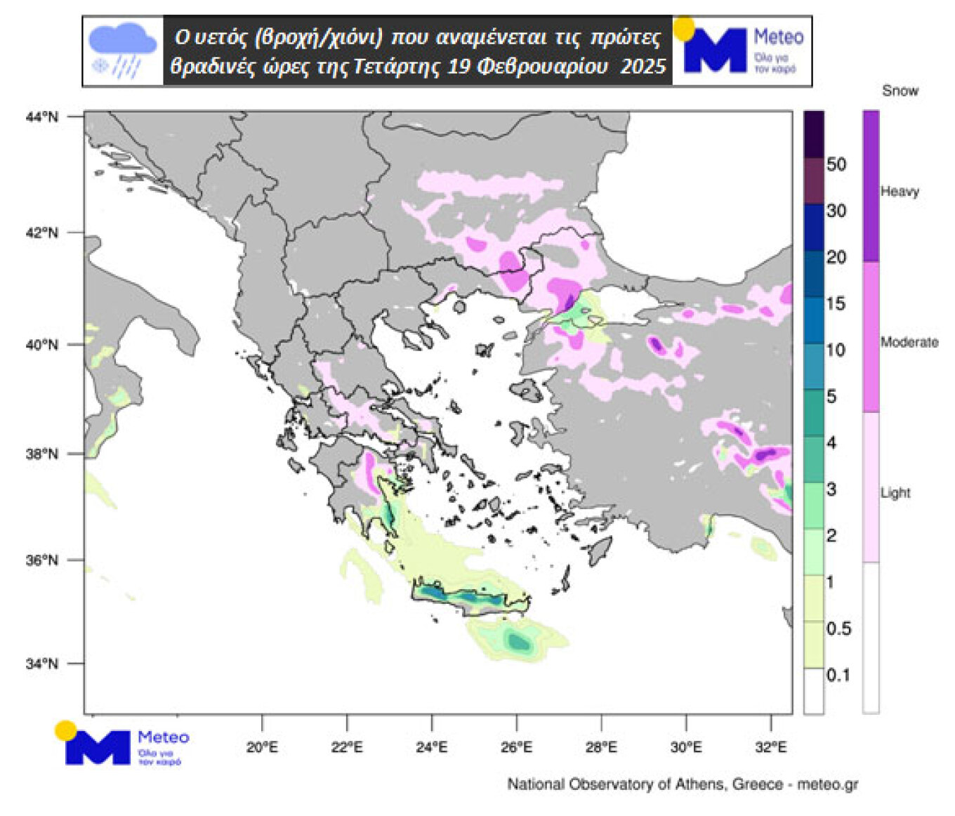
Snow is expected in the mountainous areas of these regions, in semi-mountainous areas of Thessaly, Eastern Central Greece, Eastern Peloponnese, and the eastern parts of Thrace. On maps 1 and 2, the expected rain and snow are shown, with green shades for rain and purple for snow.
Today’s Weather
More specifically, on Wednesday, clouds with local rains are expected in the eastern parts, mainly in the southern parts of Central Macedonia, Thessaly, the Sporades, Evia, Eastern Central Greece and Peloponnese, the northern and western Cyclades, and Crete. Snow will fall locally in Thrace and Macedonia, in the mountains and semi-mountainous areas of Thessaly, Central Greece, Evia, and the northern Aegean islands, as well as in mountainous areas of northern and eastern Peloponnese and Crete. In western Greece, generally sunny weather with a few clouds is expected. Winds from the north will reach 6 Beaufort in the Ionian Sea and 7 to 8 Beaufort in the Aegean. The temperature on the islands and coastal areas of the Ionian, Crete, and the Dodecanese will reach 14 to 15 degrees, while in the rest of the country, it will be 8 to 12 degrees, and in the northeast, it will not exceed 6 to 7 degrees.
Closing
In Attica, clouds with local rain and a few snowflakes in the mountains are expected. Winds will be northeasterly, gradually reaching 6 to 7 Beaufort, with the temperature reaching up to 11 to 12 degrees, and in the northern parts, 3 to 4 degrees lower.
In Thessaloniki, clouds with local rain or sleet and some snow locally in the mountains and semi-mountainous areas are expected. Winds will be northerly to northwesterly, reaching 5 and occasionally 6 Beaufort, with the temperature reaching up to 7 degrees.
Marousakis: Harsh winter on the way with strong north winds – Forecast for Attica
Meteorologist Klearchos Marousakis provided new information about the upcoming bad weather, Coral, which is expected to hit Greece in the coming hours.
In particular, as highlighted by the Open meteorologist in a Facebook post, Attica will be hit by “snow attacks” from today, Wednesday (19/2), until Sunday (23/2). He notes that through the maps he published, the exact path of the snowfalls is tracked according to a high-resolution model.
Full post
HARSH WINTER ON THE WAY
As polar air masses gradually reach our country, today will unfold with freezing cold and snow dominating the eastern and northern parts in the coming hours.
FORECAST SYSTEM “THESEUS”
According to the latest data we analyzed a little while ago, from the next few hours until tomorrow around noon, temporarily heavy snowfalls will occur in Central Macedonia, Thessaly, and in the evening in Attica-Boiotia, Evia, and Eastern Peloponnese.
From tomorrow noon until Friday morning, the weather will continue in waves, with snowfalls spreading towards Crete and the Cyclades.
AREA OUTLINE
In general, if we were to outline the areas affected by these waves of snow, we would define an area extending east of the Pindus mountain range and south of Chalkidiki, or more simply, areas that “face” the Aegean.
NEW WORSENING
A new intensification of snowfalls is expected towards the evening of Friday and into Saturday for the same areas again.
FOR ATTICA
Attica will be significantly affected by these waves of snow, especially the eastern, northern, and northwestern parts, where we can identify two notable waves.
The first from tonight until tomorrow noon and the second from Friday afternoon into Saturday.
In the interval between these two waves, weather events will occur in waves, but with lesser duration and intensity.
THE COUNTRY WILL BE IN FREEZE FOR DAYS
Great caution must be taken for the very low temperatures that will create freezing conditions with intensity and duration. Our farmers will be significantly affected by this development.
STORMY NORTH WINDS
The north winds will dominate in the coming days in the Aegean Sea and may complicate transportation, especially for smaller vessels.
POSSIBLE NEW WORSENING ON SUNDAY
On Sunday, there are signs of another worsening of the weather, affecting central, southern, and eastern parts of the country. More details will be provided in the coming days to see if this trend strengthens.
Coral Bad Weather – Ziakopoulos’ Forecast
Today, Wednesday (19/2), in Northern Greece, temporary snow or sleet (near the coast) is expected. In Thessaly, the Northern Sporades, Eastern Central Greece, Evia, and the East-Northeast Peloponnese, rain and snow (mountainous and semi-mountainous) are expected. In the rest of the country, local clouds with rain are mainly expected in the Cyclades and Crete. Winds will blow from the north-northeast, reaching up to 7 Beaufort (Aegean), and the temperature will drop throughout the country.
On Thursday (20/2), the main features of the weather will be strengthened north winds and cold. Local phenomena, usually weak, will occur mainly in eastern mainland Greece, the Cyclades, and Crete. The temperature will continue to drop slightly, especially in northern and eastern Greece. It should be noted that for snow in the lowlands and coastal northern areas, temperatures will not be low enough.
On Friday and Saturday (21 & 22/2), when some areas of the country will experience the lowest (maximum) temperatures of the week and generally of this winter, precipitation will again be limited to the east and south but will be heavier in some places. Additionally, snow is expected even in lowland areas.
Ask me anything
Explore related questions