
The weather will be improved today in most parts of the country. A few local showers are expected over northern Crete during the day and, from nighttime, over the Ionian and Epirus. The phenomena will intensify after midnight.
“From Sunday night, a new wave of bad weather will arrive from the Adriatic Sea, becoming noticeable from Monday to Tuesday. It will again bring similar phenomena – rain, local thunderstorms – even to Attica. It will ‘sweep’ across the country from northwest to southeast from Monday through Wednesday,” said Open TV meteorologist Klearchos Marousakis.
Meteorologist Giorgos Tsatrafilias added that “from Sunday night (October 5), a new organized low-pressure system coming from the northwest will cross the country, bringing considerable rainfall to most regions until Wednesday. Eastern Macedonia, Thrace, the northern and eastern Aegean, and the Dodecanese are expected to receive the highest rainfall totals. In addition, very strong northerly winds will blow, and temperatures will drop again.”
Meteorologist Theodoros Kolydas wrote about the great importance of autumn rains and the weather outlook for the coming days:
“Autumn soaking rains are a vital mechanism. They rehydrate the soil after a dry summer, preparing it for winter crops, recharge groundwater aquifers, contribute to the balance of water resources, reduce the risk of wildfires by strengthening vegetation and moisture in biomass, and finally, help maintain ecological balance by replenishing lakes, rivers, and wetlands. Their significance is even greater in countries like Greece, where water resources show strong seasonal variation and summers are extremely dry. Rain will continue into next week.”
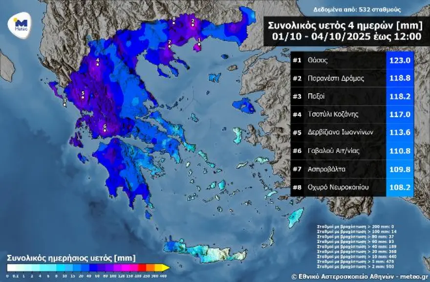
High rainfall over the past four days in Greece
The strong weather system that hit Greece in early October 2025 left high rainfall totals.
The map below shows the distribution of cumulative rainfall from Wednesday, October 1, through midday Saturday, October 4, according to the network of automatic weather stations of meteo.gr / National Observatory of Athens. The eight stations with the highest totals are also shown.
The highest rainfall was recorded on Thassos Island, where 123 millimeters fell. Significant rainfall also occurred in northern and western parts of Greece, where several stations reported high totals. Notably, 14 stations recorded more than 100 millimeters of rain in four days.
Today’s weather
Clouds are expected mainly in western and southern Greece, as well as in Thrace, the eastern Aegean, and the Dodecanese. From noon, clouds will spread to the rest of the mainland and the northern Aegean. Local showers will develop in the afternoon over the Ionian, Epirus, western Sterea, the Peloponnese, and Crete.
Temperatures:
- Western Macedonia: 2–19°C
- Central/Northern Macedonia & Thrace: 7–22°C
- Thessaly: 9–23°C
- Epirus: 7–21°C
- Sterea & Peloponnese: 9–23°C
- Ionian Islands: 12–21°C
- Northern/Eastern Aegean: 11–23°C
- Cyclades: 14–23°C
- Dodecanese & Crete: 15–24°C
Winds:
- Aegean: west 3–5 Beaufort, turning southerly by evening
- Ionian: west 2–4 Beaufort, turning southerly 3–5 Beaufort
Attica: Mostly sunny with some clouds in the afternoon. Winds southwest to west 2–4 Beaufort. Temperature 14–23°C.
Thessaloniki: Mostly sunny, becoming cloudy from the afternoon. Variable winds up to 3 Beaufort. Temperature 12–20°C.
Monday, October 6
Initially in the Ionian, Epirus, western Sterea, and western Peloponnese, clouds with rain and scattered thunderstorms. Gradually, the phenomena will extend to the rest of the country. Temporary weakening from late afternoon in the west, while rain persists elsewhere.
Winds southerly 4–5 Beaufort, turning quickly to northerly 5–6 Beaufort, strengthening.
Temperature: little change – 18–20°C in the north, 22–23°C elsewhere, up to 24–25°C in the Dodecanese, Cyclades, and Crete.
Tuesday, October 7
Unsettled weather with local rain and thunderstorms throughout the country, gradually easing in the west.
Winds: north 4–6 Beaufort, up to 7 Beaufort at sea.
Temperature: drop, mainly in central and northern areas.
Wednesday, October 8
In eastern and southern Greece: clouds, local rain, and isolated thunderstorms at times, gradually improving. Elsewhere, clouds with brief showers.
Winds: north 5–6 Beaufort, up to 7 Beaufort at sea, weakening by evening.
Temperature: little change.
Thursday, October 9
In eastern Greece: clouds with local showers, possibly isolated morning storms, quickly improving. Elsewhere, few clouds.
Winds: north-northwesterly 4–5 Beaufort, locally up to 6.
Temperature: slight rise.
Ask me anything
Explore related questions