
Instability will persist on Sunday as well, bringing rain and thunderstorms to a large part of the country. The day is expected to be rainy with local thunderstorms mainly in the western part of the country and local cloudiness and rain in the rest. In the early hours of Sunday, after 04:00, we had torrential rain in Ilia and heavy rain in Zakynthos. We had rainfall in almost all of Central Greece and Thessaly, in Epirus and Macedonia — in places even strong — but also in eastern Attica.
On Sunday the temperature will not exceed 24 degrees, while in the north it will be somewhat lower. The weather pattern will not change significantly on Monday and only from Tuesday will conditions improve.
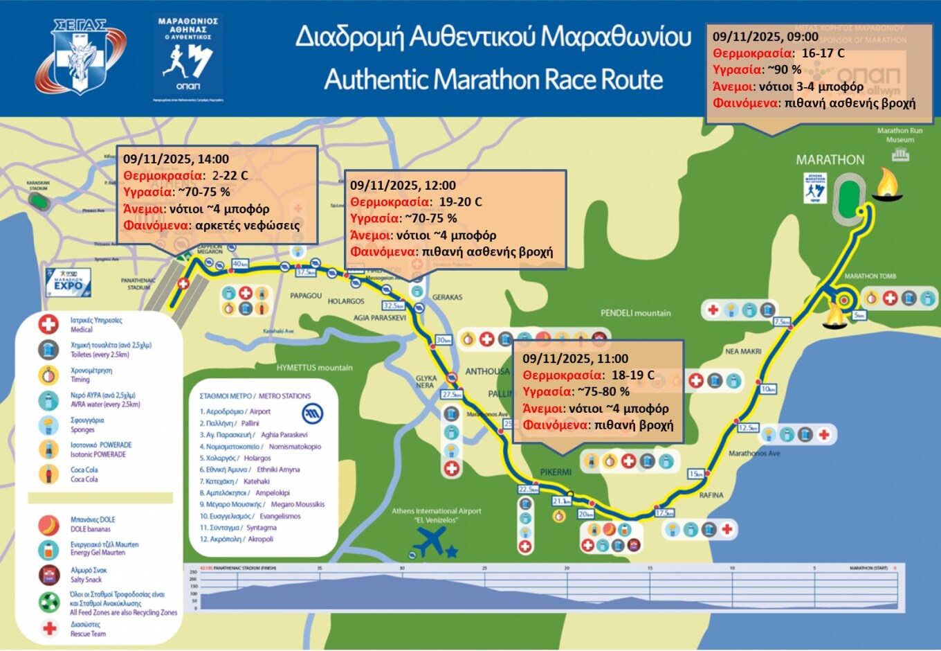
What weather the Marathon will have
According to meteo.gr in its forecast, the 42nd Athens Authentic Marathon will take place with plenty of cloud cover and increased probability of light rain at times. High relative humidity values are expected along most of the route, but will decrease approaching the finish. At the same time south winds of around 4 Beaufort will be blowing, while temperature will range between 17-19°C in the first half of the route and between 20-22°C in the second half.
In the image the route is shown as well as the weather conditions expected along it, at indicative time points.
EMY forecast for Sunday
Locally strong rain and thunderstorms in the Ionian, Epirus and western Central Greece, mainly until noon and again from the evening onwards.
GENERAL CHARACTERISTICS
In the west: clouds with local rain and scattered thunderstorms, locally strong in the Ionian, Epirus and western Central Greece mainly until noon and again from the evening.
In the rest of the country: clouds at times increased with local rains. Scattered thunderstorms mainly in eastern Macedonia, Thrace and the northeastern Aegean.
Winds: south southeasterly 4-6 Beaufort and in the Ionian locally 7 Beaufort temporarily.
Temperature: will reach 18-20 degrees in the north and 21-24°C in the rest of the regions.
MACEDONIA, THRACE
Weather: Increased cloudiness with local rains. Scattered thunderstorms mainly in eastern Macedonia and Thrace.
Winds: southerly 3-5 Beaufort.
Temperature: 12 to 20°C. In western Macedonia 4-5 degrees lower.
IONIAN ISLANDS, EPIRUS, WESTERN CENTRAL GREECE, WESTERN PELOPONNESE
Weather: Clouds with local rain and scattered thunderstorms, locally strong in the Ionian, Epirus and western Central Greece mainly until noon and again from the evening.
Winds: south southeasterly 4-6 Beaufort and locally 7 Beaufort in the Ionian temporarily.
Temperature: 15 to 23°C. In interior Epirus 4-5 degrees lower.
THESSALY, EASTERN CENTRAL GREECE, EVIA, EASTERN PELOPONNESE
Weather: Clouds periodically increased with local rain and possibly isolated thunderstorms, mainly in Thessaly from the evening.
Winds: southerly 3-5 Beaufort and locally 6 Beaufort in the east and south.
Temperature: 13 to 24°C.
CYCLADES, CRETE
Weather: Few clouds periodically increased with probability of local rains or isolated thunderstorms mainly in the northern Cyclades in the morning.
Winds: southerly 3-5 Beaufort and locally 6 Beaufort in the west.
Temperature: 15 to 24°C.
EASTERN AEGEAN ISLANDS – DODECANESE
Weather: Few clouds periodically increased with local rains mainly in the Eastern Aegean islands until noon where scattered thunderstorms will also occur.
Winds: southerly 3-5 Beaufort and locally 6 Beaufort in the north.
Temperature: 15 to 23°C.
ATTICA
Weather: Few clouds at times increased with possibility of local rain.
Winds: southerly 4-6 Beaufort.
Temperature: 15 to 23°C.
THESSALONIKI
Weather: Increased cloudiness with local rains and possibly isolated thunderstorms mainly from the evening.
Winds: variable 3-4 Beaufort.
Temperature: 13 to 19°C.
FORECAST FOR MONDAY 10-11-2025
In the Ionian and the mainland: increased clouds with local rains and scattered thunderstorms, locally strong in central and eastern Macedonia, until noon in the Ionian, western Central Greece and Epirus and until evening in the western Peloponnese.
In the rest of the country: few clouds temporarily increased with local rain. Isolated thunderstorms will occur from the afternoon at places in the central and northern Aegean and from evening in western Crete.
Winds: south southeasterly 3-5 Beaufort and locally 6 Beaufort in the seas, turning late afternoon in the Ionian to west northwest 3-5 Beaufort.
Temperature: no significant change except slight drop in the northwest. Will reach 18-20°C in the north and 22-24°C elsewhere and 25°C in Crete.
FORECAST FOR TUESDAY 11-11-2025
In eastern Macedonia, Thrace, eastern Aegean islands, Dodecanese and temporarily in the Cyclades: clouds with rain and scattered thunderstorms. Phenomena possibly locally strong in the morning hours, gradually weakening from afternoon in most areas.
In the rest of the country: unstable weather periodically cloudy with local rains and temporarily mainly in central Macedonia and Crete, isolated thunderstorms. Gradual improvement from afternoon.
Visibility in the morning and evening hours in the west will be locally reduced.
Winds: west northwest and in the eastern Aegean until noon southerly 4-5 Beaufort, temporarily locally up to 6 Beaufort in the seas.
Temperature: slight drop mainly in the north.
Ask me anything
Explore related questions