A significant change in weather conditions is being brought by a new wave of severe weather, with the main characteristics being gale-force winds, heavy rainfall, and a sharp drop in temperature. The phenomena have already caused problems in Achaia and Evrytania, flooding has occurred in Epirus, while the sea overflowed onto land in Nafplio and Rio.
According to Thodoris Kolydas, the weather change starting tomorrow, Sunday, marks a temperature drop that will initially be noticeable in the north and will gradually extend to the rest of the country. In many areas of the central and northern mainland, maximum temperatures will remain in single digits, giving the weather a clearly wintry character. Overall, the drop is estimated to be around 10 degrees Celsius, as the meteorologist notes.
On Monday 12/1 and Tuesday 13/1 the cold intrusion will peak, with temperatures falling further and frost appearing during the morning hours, predicts Thodoris Kolydas. He does not rule out temperatures dropping below 0 degrees Celsius even in lowland areas of the central and northern mainland, a factor that requires increased caution, especially when traveling during the early hours of the day. From Tuesday onward, however, a gradual rise in temperatures in terms of maximum values is expected, with Wednesday returning to levels slightly above normal for the season.
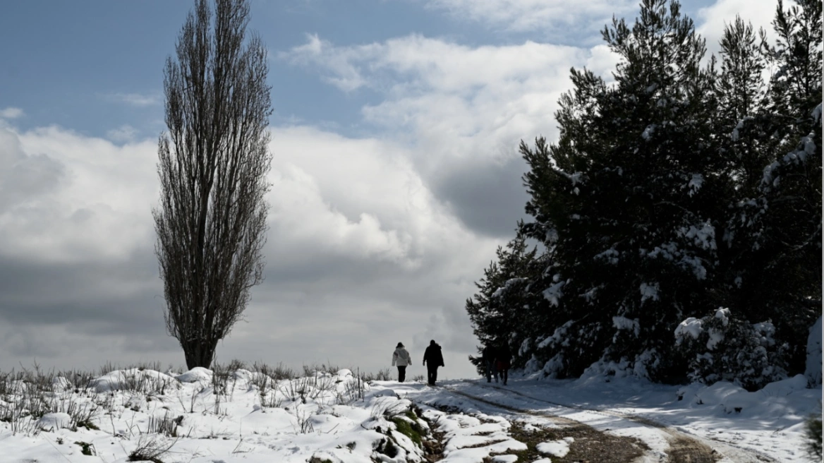
As for precipitation and especially snowfall, snow will mainly affect mountainous and semi-mountainous areas of the country. For Sunday, the Hellenic National Meteorological Service (HNMS) forecasts local rain in the west and isolated thunderstorms in the eastern Aegean. Snowfall will occur in mountainous areas and, from the evening onward, also in parts of northeastern Greece at lower altitudes.
On Monday, in Thrace, eastern and central Macedonia, the islands of the northeastern Aegean, the Sporades, Thessaly, eastern Central Greece, Evia, and eastern Peloponnese, rain or sleet is expected, and in areas with elevations above approximately 300 meters, temporary snowfall. From late afternoon, the phenomena will stop in most areas.
According to Mr. Kolydas, in cities—and especially in Attica—the temperature thresholds in the upper atmosphere remain precarious, which does not yet allow for clear conclusions regarding snowfall. Uncertainty among forecasting models remains high, and a more reliable assessment is expected tomorrow, Sunday, approximately 24 hours before the most critical time periods, as he characteristically notes.
The sea overflowed onto land in Nafplio and Rio
Residents and shop owners in the city of Nafplio were faced with a difficult situation, as gale-force winds caused strong waves and the sea entered the old town. As a result, streets were flooded and traffic was interrupted on Amalias and Syngrou streets, according to argolikeseidhseis.gr.
Similar scenes were recorded in Rio, where severe weather and strong southwesterly winds caused a rise in sea level and overflow of water onto the coastal road. The area resembled scenes from… Venice, with water covering parts of the roadway and creating serious traffic problems.
Gale-force winds in the Antirrio area resulted in flooding of roads on the western pier.
Problems were also recorded in Patras, both in the city center and in neighborhoods such as Ovrya and Rio, where trees that could not withstand the force of the wind collapsed onto roads and sidewalks.
The city also experienced heavy hail, causing disruption among residents and drivers and confirming the intensity of the severe weather sweeping western Greece.
Within a few minutes, roads, sidewalks, and yards were covered with layers of hail. The phenomenon was accompanied by heavy rainfall and strong winds, resulting in traffic problems as visibility was significantly reduced.
High waves at the port of Tinos
Strong southerly winds blowing today in Tinos are significantly affecting the island, with increased wind intensity and strong wave activity, mainly in the south and at the outer harbor. According to tinostoday.gr, weather conditions are making travel difficult for both vehicles and pedestrians, while stones and objects have been carried onto the roadway in some areas. Particular caution is required in the wider port area, where waves are high and wind gusts are strong. Drivers are advised to proceed at low speeds and, where possible, to avoid unnecessary travel.
Landslides due to severe weather in the Municipality of Agrafa
Severe weather also caused problems in mountainous Evrytania. Heavy rainfall led to rockfalls and road network issues, creating difficulties for residents’ movements.
As reported in a briefing by the Mayor of Agrafa, Alexis Kardabikis, from the early morning hours, crews from the Municipality and the Region were on site, intervening wherever necessary. Rockfalls on the main road to the village of Agrafa, in Stana, as well as on the road to Agios Nikolaos, were immediately cleared to ensure traffic flow.
According to lamianow.gr, the situation remains particularly difficult in Kryoneri, where a serious problem occurred at the pumping station. The large volume of water and torrential streams currently prevent crews from accessing the area, with the Municipality seeking ways to intervene safely once conditions allow.
@lamianow.gr Σοβαρά προβλήματα προκαλεί η κακοκαιρία που χτυπά τις τελευταίες ώρες την ορεινή Ευρυτανία ☔⛰️ Στον Δήμο Αγράφων, από νωρίς το πρωί, συνεργεία του Δήμου και της Περιφέρειας βρίσκονται στο πεδίο, αντιμετωπίζοντας καταπτώσεις βράχων και επικίνδυνα σημεία στο οδικό δίκτυο. Όπως ενημέρωσε ο δήμαρχος Αγράφων, Αλέξης Καρδαμπίκης, έχουν ήδη δοθεί λύσεις σε δρόμους προς Άγραφα, Στάνα και Άγιο Νικόλαο. Δύσκολη παραμένει η κατάσταση στο Κρυονέρι, όπου η μεγάλη ποσότητα νερού δεν επιτρέπει ακόμη την προσέγγιση στο αντλιοστάσιο. #Άγραφα #Ευρυτανία #Κακοκαιρία #Προσοχή #ΣεΕπιφυλακή
♬ πρωτότυπος ήχος – Lamianow.gr
The mayor called on citizens to show understanding and increased caution, avoiding unnecessary travel, as the mountainous road network remains dangerous. “We are standing by our residents and closely monitoring the evolution of the severe weather,” he stated, emphasizing that the Municipality of Agrafa will continue its efforts on the ground until the situation fully normalizes.
Problems in Epirus
Problems were caused by the rise in the water level of the Kalamas River in the area of Chani Tsika in the Municipality of Zitsa, resulting in flooding of the Agrotissa park and extensive agricultural land in the plain, according to epirusgate.gr.
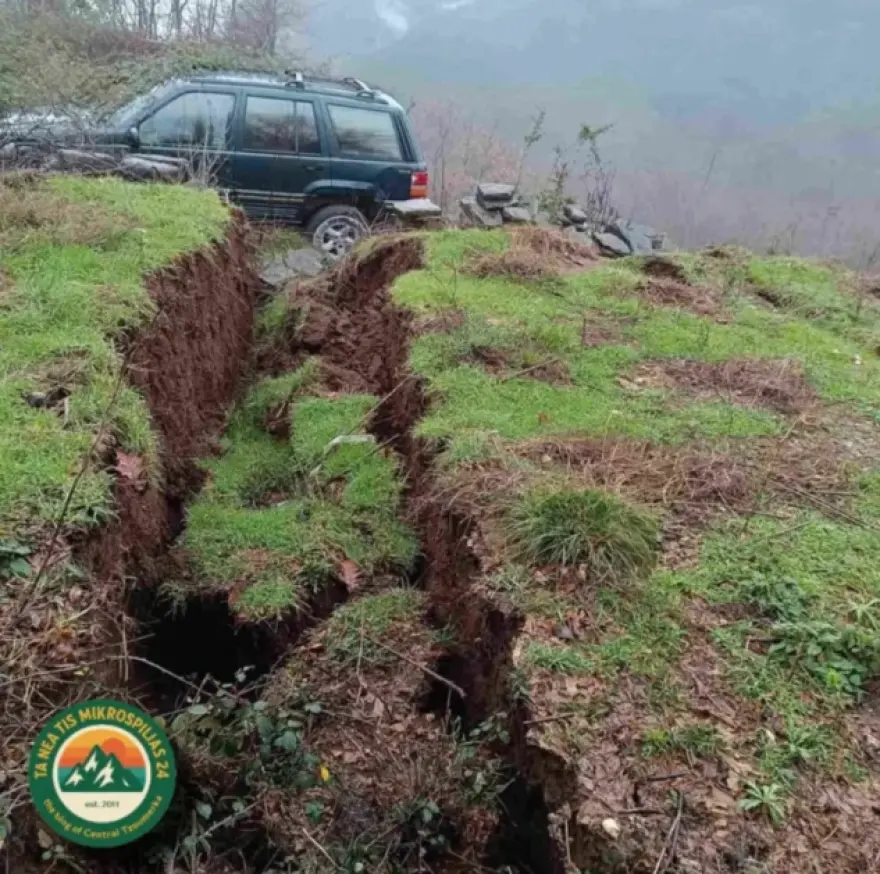
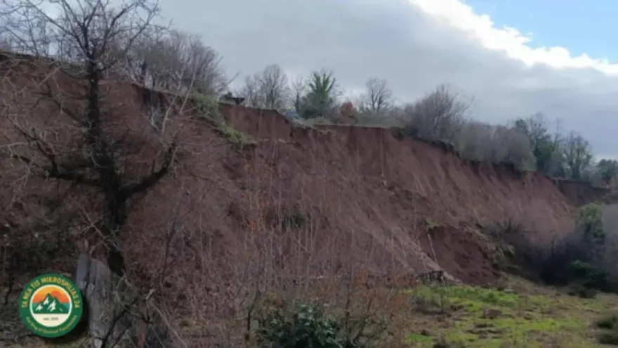
At the same time, concern has been raised among residents of Mikrospilia in the Municipality of Central Tzoumerka due to a landslide that occurred at the location “Campos,” as reported by epiruspost.gr. According to residents’ testimonies, the slope collapsed over a large area, with the ground shifting abruptly and deep cracks forming, revealing serious ground instability.
Traffic conditions are difficult on the road from Milia to Metsovo due to heavy snowfall and dense fog. According to the same information, visibility is limited at several points on the road network, while the road surface has begun to be covered with snow, increasing the risk of slipperiness.
Drivers are urged to be particularly careful, drive at low speeds, and maintain safe distances. The use of snow chains is recommended, especially for vehicles without winter tires.
Calls to the Fire Service
A total of 103 calls have been received by the Operations Center of the Fire Service due to strong winds in the Regions of the Peloponnese, Western Greece, and Central Greece from this morning until 17:00. The calls mainly concern tree cutting, removal of objects, and water pumping.
In detail, the Fire Service Operations Center has received:
In the Region of the Peloponnese: 33 calls, with 24 tree cuttings and 3 object removals carried out so far
In the Region of Western Greece: 47 calls, with 40 tree cuttings, one water pumping operation, and 6 object removals carried out so far
In the Region of Central Greece: 23 calls, with 14 tree cuttings and one object removal carried out so far
Finally, the Fire Service calls on citizens to be particularly careful and to follow the instructions of the competent authorities.
Forecast for Sunday
Warnings: Possibly heavy rain and thunderstorms locally in the Dodecanese. During the morning hours, gale-force westerly–southwesterly winds up to 8 Beaufort in Crete, the Cyclades, and the Dodecanese, and during the evening hours gale-force northerly–northwesterly winds up to 8 Beaufort locally in central Macedonia.
Increased cloudiness with local rain and isolated thunderstorms in the west and the eastern Aegean, possibly locally strong in the Dodecanese. Snowfall will occur in mountainous and northern semi-mountainous areas and, from the evening hours, also in areas of northeastern Greece at lower altitudes.
Winds in the south will blow from westerly directions at 5 to 7 Beaufort, and during the morning hours locally 8 Beaufort at sea. In the north, winds will blow from northerly directions at 4 to 6 Beaufort, gradually strengthening to 5 to 7, and in the northern Aegean during the evening hours locally up to 8 Beaufort.
Temperatures will drop, noticeably in the north, where they will not exceed 6 to 8°C, while in the rest of the country they will reach 9 to 15°C and in the Cyclades, Crete, and the Dodecanese 16 to 18°C. Frost will occur in the central and northern mainland.
Detailed forecast:
ATTICA
Weather: Periods of increased cloudiness with local rain, mainly during midday and afternoon hours.
Winds: Westerly–southwesterly 4 to 6 Beaufort, turning to northerly–northwesterly in the afternoon with the same intensity.
Temperature: 5 to 15°C.
THESSALONIKI
Weather: Cloudiness with local rain and snowfall in mountainous and semi-mountainous areas, gradually improving from the afternoon.
Winds: Northerly–northwesterly 4 to 6 Beaufort, locally 7 from midday and up to 8 Beaufort in the evening.
Temperature: 0 to 8°C.
MACEDONIA, THRACE
Weather: Cloudiness with local rain and mainly in coastal areas isolated thunderstorms. Snowfall in mountainous and semi-mountainous areas and, from the evening, also in low-altitude areas of eastern Macedonia and Thrace. Gradual improvement in western and central Macedonia during the evening.
Winds: Northerly 4 to 6 Beaufort, locally 7 from midday, and up to 8 Beaufort locally in central Macedonia during the evening.
Temperature: 0 to 8°C. In western Macedonia 4 to 5 degrees lower.
IONIAN ISLANDS, EPIRUS, WESTERN CENTRAL GREECE, WESTERN PELOPONNESE
Weather: Cloudiness with local rain and mainly during morning hours isolated thunderstorms in the Ionian Islands, western Central Greece, and western Peloponnese. Snowfall in mountainous mainland areas and semi-mountainous areas of Epirus. Gradual improvement in most areas during the evening.
Winds: Westerly–northwesterly 4 to 6 Beaufort, locally 7 in the Ionian and up to 8 Beaufort in the south during the morning.
Temperature: 2 to 14°C. In the interior of Epirus 4 to 5 degrees lower.
THESSALY, EASTERN CENTRAL GREECE, EVIA, EASTERN PELOPONNESE
Weather: Periods of increased cloudiness with local rain and isolated thunderstorms mainly during midday and afternoon. Snowfall in mountainous mainland areas and the mountains of Evia.
Winds: Westerly–southwesterly 4 to 6 Beaufort and in the south up to 7 to 8 Beaufort. Gradually turning from the north to northerly–northwesterly 4 to 6 Beaufort and up to 7 Beaufort in the north.
Temperature: 3 to 15°C. In the north 3 to 4 degrees lower.
CYCLADES, CRETE
Weather: Periods of increased cloudiness with local rain and isolated thunderstorms.
Winds: Westerly–southwesterly 6 to 8 Beaufort, turning to westerly–northwesterly 5 to 7 Beaufort in the afternoon.
Temperature: 10 to 18°C.
EASTERN AEGEAN ISLANDS – DODECANESE
Weather: Cloudiness with rain and isolated thunderstorms, possibly locally strong in the Dodecanese.
Winds: In the south, westerly–southwesterly 5 to 7 Beaufort, locally up to 8 Beaufort in the morning, gradually turning to westerly–northwesterly with the same intensity. In the north, westerly–southwesterly 5 to 7 Beaufort, quickly turning to northerly–northeasterly and strengthening to 8 Beaufort in the evening.
Temperature: 8 to 18°C. In the north 2 to 3 degrees lower.
Weather on Monday, January 12
In the Ionian, a few temporary clouds until midday. In western Macedonia, Epirus, western Central Greece, and western Peloponnese, cloudiness with local rain or sleet and snowfall in mountainous and semi-mountainous areas, clearing to mostly fair weather from midday.
In Thrace, central and eastern Macedonia, the islands of the northeastern Aegean, the Sporades, Thessaly, eastern Central Greece, Evia, and eastern Peloponnese, sleet, isolated thunderstorms over the sea, and temporary snowfall in mountainous and semi-mountainous areas (above approximately 300 meters). Note that in Thrace and eastern Macedonia, snowfall will also occur temporarily in lowland areas (above approximately 100 meters). From late afternoon, phenomena will stop in most areas. In the Cyclades, Crete, and the Dodecanese, local rain, isolated thunderstorms, and local snowfall in the mountainous areas of Crete and the Cyclades.
Winds will blow from northerly directions at 5 to 6 Beaufort, and at sea 7 to locally 8 Beaufort. Temperatures will drop further across the country. Minimum temperatures in the north will range from -3 to -5°C, in the northwest from -6 to -10°C, and in the central mainland from -3 to 0°C. Maximum temperatures in the north will not exceed 5°C, in the eastern mainland 6 to 8°C, while in the west, the Cyclades, and Crete they will reach 9 to 11°C and in the Dodecanese 11 to 13°C.
Frost will occur on the mainland, total and locally severe in the north.
Weather on Tuesday, January 13
In Crete and the southern Aegean, cloudiness with local rain, weak snowfall in mountainous areas, and rapid improvement. In the rest of the country, generally fair weather with a few local clouds.
Winds will blow from northerly directions at 4 to 6 Beaufort and in the southern Aegean 7 to locally 8 Beaufort, gradually weakening from the north. Temperatures will show a slight rise in maximum values. Frost will occur on the mainland, locally strong in central and northern areas.
Forecast for Wednesday, January 14
Generally fair weather with local clouds. Winds in the south will be northwesterly 4 to 5 Beaufort, and in other areas variable 2 to 4 Beaufort. Temperatures will rise, though early in the morning frost will occur locally on the mainland.
Weather on Thursday, January 15
Generally fair weather with local clouds. Visibility will be locally limited during morning and evening hours. Winds in the east will blow from northerly directions at 3 to 5 Beaufort, and in the west will be variable at 2 to 4 Beaufort. Temperatures will not change significantly, though early in the morning frost will occur locally in the northwestern mainland.
Ask me anything
Explore related questions