Greece is entering a period of severe winter weather starting today, Monday, with a sharp drop in temperatures, snowfall even at low elevations, widespread frost, and strong northerly winds, according to the emergency weather bulletin issued by the Hellenic National Meteorological Service (HNMS). An orange-level warning is in effect, with hazardous conditions expected to persist through Wednesday.
The HNMS reports that very low temperatures will continue until the morning of Wednesday, January 14, with frost occurring mainly during the morning and evening hours, locally severe in northern regions. Northerly winds reaching 7 to 8 on the Beaufort scale are expected in some areas through Monday evening. Snowfall has already been recorded in parts of northern Greece, including Drama, Kavala, Halkidiki, and Rodopi, marking the beginning of a broader cold spell affecting much of the country.
According to the emergency bulletin, snowfall will affect mountainous and semi-mountainous areas of mainland Greece and Evia, while from tonight it will also reach low-lying areas of Eastern Macedonia and Thrace, the regional units of Serres and Halkidiki, eastern parts of Thessaloniki, and islands of the Northern Aegean such as Lemnos, Lesvos, Chios, and the Sporades. From early Monday morning, snow is also expected in low-lying areas of Evia, mainly in the eastern parts, as well as in the mountainous and semi-mountainous areas of the Cyclades and Crete. Snowfall will gradually weaken before noon in northern regions and from the afternoon in most other areas, with the exception of the mountainous and semi-mountainous parts of Crete, where snow is expected to continue until Tuesday morning.
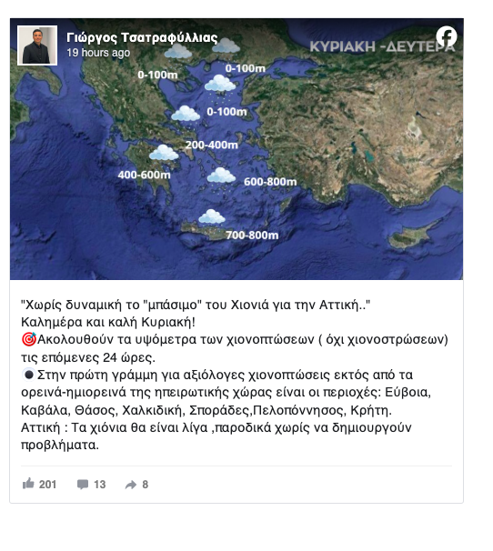
Meteorologist Giorgos Tsatrafyllias stated that the cold front affecting Attica is not expected to have strong intensity. He noted that during the next 24 hours, snowfall, without significant accumulation, will mainly affect Evia, Kavala, Thassos, Halkidiki, the Sporades, the Peloponnese, and Crete, while in Attica any snowfall will be limited and brief, without causing major problems.
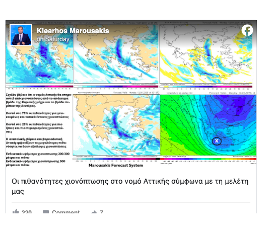
On the other hand, meteorologist Klearchos Marousakis reported increased chances of snowfall in Attica through Monday evening. According to his analysis, the probability of widespread and locally intense snowfall is around 75 percent, while the chance of lighter and more limited phenomena is about 25 percent. Areas most likely to experience notable snowfall include eastern, northern, and northwestern parts of Attica. Snowfall is expected at elevations of approximately 200 to 300 meters, while snow accumulation is more likely above 500 meters.
Authorities are urging the public to exercise increased caution when traveling, particularly during the early morning and evening hours, due to frost and reduced visibility. The cold wave is expected to last for several days, making weather conditions demanding across large parts of the country, especially in mountainous and northern regions.
For today, cloud cover is expected in Thrace, Eastern Macedonia, Halkidiki, the Aegean, Evia, and Crete, gradually becoming limited to the Aegean and Crete, while the rest of the country will see temporary clouds mainly over mountainous mainland areas. Snowfall is expected in Thrace, Eastern Macedonia, Halkidiki, parts of the northeastern Aegean, Evia, Eastern Central Greece, and the Peloponnese until morning, and in the mountainous areas of Crete until the afternoon. Rain is expected in parts of the Aegean and in low-lying areas of Crete.
Temperatures will range from minus 9 to minus 2 degrees Celsius in Western Macedonia, from minus 6 to 4 in the rest of Macedonia and Thrace, from minus 4 to 5 in Thessaly, from minus 5 to 6 in Epirus, from minus 3 to 8 in Central Greece and the Peloponnese, from 1 to 6 on the Ionian Islands and in the Northern and Eastern Aegean, from 4 to 8 in the Cyclades, from 6 to 11 in the Dodecanese, and from 3 to 11 in Crete. Minimum temperatures in the Aegean and Crete are expected toward the end of the 24-hour period. Winds over the seas will blow from northerly directions at 5 to 7 Beaufort.
In Attica, short periods of cloudiness are expected along with long sunny intervals, with northerly winds of 3 to 5 Beaufort and temperatures in central Athens ranging between 2 and 5 degrees Celsius. In Thessaloniki, mostly sunny conditions are forecast, with northwesterly winds of 2 to 4 Beaufort, locally up to 5 in western parts of the prefecture, and temperatures ranging from minus 3 to 2 degrees Celsius in the city center.
On Tuesday, the weather in Crete, the eastern Cyclades, and the Dodecanese will include cloud cover with local rain and light snowfall in mountainous and semi-mountainous areas of Crete, followed by rapid improvement. In the rest of the country, conditions will be generally clear with local cloudiness in Macedonia and Thrace and later in the day in Thessaly and the eastern Aegean islands. Northerly winds will blow at 4 to 6 Beaufort, reaching 7 to 8 in the southern Aegean before gradually weakening. Although temperatures will remain low, daytime highs will rise slightly, reaching 5 to 7 degrees in northern mainland areas, 8 to 11 in central regions, and 11 to 14 elsewhere, while frost will persist across inland areas, locally severe in the north.
On Wednesday, the weather will be generally clear with some cloud cover in western regions, Crete, and Thrace, while locally reduced visibility is expected in western areas during the morning. Winds will shift to west and northwest at 3 to 5 Beaufort, locally up to 6 in southern areas, and temperatures will rise, although morning frost will still occur in inland regions.
On Thursday, generally fair weather is expected with some cloud cover in western, southern, and eastern island regions, along with locally reduced visibility in the morning and evening. Winds will blow from the west at 3 to 5 Beaufort, and temperatures will remain largely unchanged, though local frost may occur early in the morning in northwestern mainland areas.
On Friday, thin cloud cover is forecast, locally thicker in western and northeastern regions, with reduced visibility during morning and evening hours. Winds will be southerly at 2 to 4 Beaufort in western areas and northerly at 3 to 5 Beaufort in eastern regions, while temperatures are not expected to change significantly.
Ask me anything
Explore related questions