Greece now has its own eyes in space. Five Greek microsatellites, launched in late November last year, are now in orbit around the Earth as part of the National Microsatellite Programme and have already begun producing results.
For Greece, space is no longer a joke or a distant ambition, as it may once have seemed. The project, implemented under the auspices of the Ministry of Digital Governance, was designed to deliver practical solutions, ushering public administration, security, and sustainable development into a new era through the systematic use of satellite data generated by Greece’s own space programme.
Two operational microsatellites are already active in orbit, alongside three experimental and research satellites aimed at testing new space technologies developed in Greece, intending to strengthen the domestic space and technology industry. Through the structured exploitation of satellite data, the country is entering a new era that promises tangible benefits for citizens.
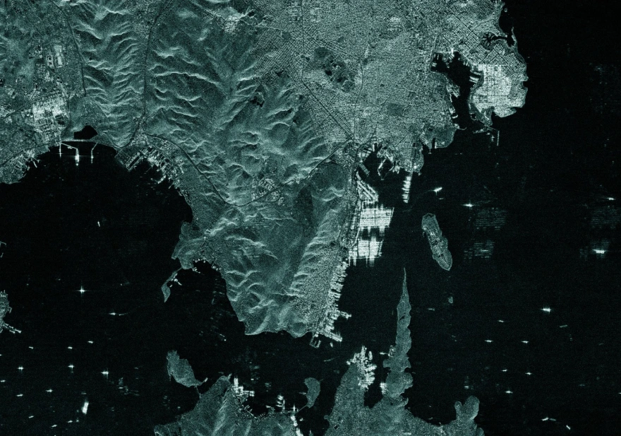
The Athens–Macedonian News Agency (ANA-MPA) today presents the first images captured by the microsatellites.
The first image, taken on 13 December 2025, shows the ports of Piraeus and Perama.
The second high-resolution optical satellite image is of symbolic significance, as it captures the Belharra-class frigate Kimon on 15 January 2026, arriving in Greece from France to join the fleet of the Hellenic Navy.
From Vision to Reality
“The prospect of Greece having a presence in space once seemed either laughable or utopian. Fortunately, those days are behind us,” said Minister of Digital Governance Dimitris Papastergiou in comments to ANA-MPA.
“Just a month and a half after launch, we already have the first images from the satellites of the National Microsatellite Programme. This is a milestone that confirms Greece’s transition from planning to implementation, securing a meaningful presence in space with immediate benefits for both the state and citizens.”
Beyond their symbolic value, Papastergiou stressed the practical importance of the programme. Satellite data will be used to strengthen public administration, improve decision-making, and design more effective policies in critical sectors.
In agriculture, satellite data ensures transparency in subsidies and provides valuable information to farmers. In environmental protection, they allow continuous monitoring of forests, water resources, and protected areas. In civil protection, they support early prevention, rapid response, and accurate damage assessment during crises. In defence, they enhance surveillance of areas of interest.
Funded through the Recovery and Resilience Facility, Greece is investing in cutting-edge technologies to promote growth, security, and a sustainable future.
A Central Space Data Infrastructure
Greece is also developing a unified, central digital platform that will collect and process data from both Greek and international satellites. This infrastructure will convert space-based information into actionable policy tools, significantly impacting everyday life.
The platform will serve as the operational core of the state, managing data collection, image scheduling, storage, and processing. It will allow ministries and public services to access reliable, up-to-date satellite data without requiring specialised technical expertise. The central hub will be based in Athens and will work in cooperation with the Hellenic Space Centre.
In practice, Greece will gain the ability to systematically map its entire territory and respond rapidly to critical events. Optical, thermal, and radar data will provide continuous coverage day and night, even in cloudy conditions, with multiple daily passes ensuring up-to-date situational awareness.
From Agriculture to National Security
Satellite data play a crucial role in agriculture, enabling accurate mapping of farmland, verification of crops, and fairer, faster subsidy checks with reduced bureaucracy. Farmers also gain insights into crop health, irrigation needs, and extreme weather impacts.
Environmental monitoring benefits include continuous observation of forests, water bodies, Natura 2000 areas, coastal zones, and ecosystems under pressure, transforming climate change from an abstract concept into measurable data.
In civil protection, satellites support early detection of wildfires, flood monitoring, and damage assessment, enabling faster evacuations and more effective emergency responses.
At sea, Greece gains comprehensive situational awareness across the Eastern Mediterranean, improving border surveillance, maritime safety, migration management, and the protection of critical infrastructure.
Defence and national security are also significantly enhanced through multisensor monitoring, strategic autonomy, and full national control of sensitive data under strict cybersecurity standards.
Building Greece’s Digital Nervous System from Space
The same infrastructure will act as a catalyst for innovation and economic growth. Research centres, universities, and businesses will gain access to high-value datasets, enabling the development of advanced applications, AI-driven services, and commercially viable solutions with global reach.
In this way, Greece is building its digital “nervous system” from space: a unified, intelligent, and secure infrastructure that connects cutting-edge technology with real societal needs, strengthening resilience, state effectiveness, and the country’s digital transformation.

Ask me anything
Explore related questions