Portugal is at the mercy of storm “Ingrid”, with authorities issuing strong warnings and recommending that people avoid unnecessary travel and movement until Saturday evening.
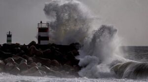
Along the entire western coastline, which has been placed under a red alert, waves could reach heights of up to 15 meters, while heavy rainfall, thunderstorms, and strong winds are forecast. At the same time, snowfall is expected even in areas where such phenomena are unusual.
According to the Portuguese Institute for Sea and Atmosphere (IPMA), snow accumulation is forecast at altitudes as low as 200 meters in the northern and central parts of the country. The regions of Porto, Viana do Castelo, Braga, Vila Real, and Viseu have been placed under red alert.
Civil Protection authorities have recommended the closure of roads, schools, and non-essential services in these areas, while the remaining regions of mainland Portugal are under yellow warning due to locally heavy rainfall.
Wind gusts could reach 100 km/h, especially in mountainous areas. Since Thursday, authorities have already had to respond to more than 400 incidents, most of them involving fallen trees.
The arrival of the storm has also led to preventive measures in various parts of the country, such as the controlled release of water from major dams. In the Algarve, where dams are currently at an average 88% capacity, outflows have begun at five of the region’s six dams, with Bravura being the only exception.
The Bravura dam, currently at about 70% of its capacity, may begin releasing water in the coming days. This situation contrasts sharply with previous years, when at the height of the drought water levels had fallen below 20%.
Although the expected increase in river flows is not considered extreme, the president of the Portuguese Environment Agency (APA), José Pimenta Machado, warned via the newspaper Diário de Notícias that people living or moving downstream of dams should be particularly cautious and avoid rivers and flood-prone areas.
Ask me anything
Explore related questions