The weather deteriorates again today, Thursday 5/02, with showers and thunderstorms that will be locally heavy, very strong winds from southerly directions, and increased concentrations of African dust. The bad weather affecting the country has already caused significant damage in Corfu and flooding in Kefalonia.
According to meteo.gr/ EAA forecast data, showers and thunderstorms will occur from the beginning of the day, mainly in the western and northern parts of the country, which will gradually expand to most areas of the country, while in the evening, they will be limited in Thrace, the East Aegean islands, and the Dodecanese. The phenomena will be locally strong and in some places will be accompanied by hail.
The areas with the highest probability of hail are the Ionian Islands, the western mainland, the Peloponnese, the East Aegean islands, and the Dodecanese. Atmospheric conditions favour the transport of dust from Africa and the occurrence of mud showers.
The rainfall episode is classified as Category 3 (Significant)
Precipitation will occur at times in the prefecture of Attica and the city of Athens, while thunderstorms are expected mainly during the afternoon and evening hours.
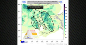
The forecast maps show the cumulative rainfall on Thursday, 05/02, as well as the estimated geographical distribution of African dust and mud showers during the midday hours of the day, according to the DUST-WRF system of Meteo.gr/National Observatory of Athens. The DUST-WRF system provides high-resolution forecast maps for dust transport and deposition in the Eastern Mediterranean and Greece.
At the same time, very strong and locally gusty winds from southern directions will blow in the Aegean Sea.
Live map showing the path of the bad weather
How bad weather will move today, the map shows where mud showers, flooding in Kefalonia, and tornadoes in Corfu
The bad weather from the west of the country began with intensity on Wednesday evening, causing widespread damage in Corfu and flooding in Kefalonia, while forecasters say the worsening weather is expected to affect Attica from today, with rain, thunderstorms, and increased winds.
According to local reports, a tornado hit the village of Afionas, in the northwestern part of Corfu. Its passage caused serious property damage, as at least three residential roofs were swept away by the strong winds, while a pavilion of the municipality was also destroyed.
Gusty winds caused problems in both the northern and southern parts of the island.
Tree limbs fell on the roadway, impeding traffic and necessitating the immediate intervention of the Fire Department to remove them.
At the same time, heavy rainfall hit Kefalonia, resulting in flooding in various areas of the island. The local authorities are closely monitoring the development of the bad weather, as the phenomena are expected to continue in the coming hours.
EMY: Special weather bulletin
HEME. 4/2026 issued on Wednesday at 12.00 noon is still valid according to the latest forecast data.
Hhihh>The Special Weather Forecast Order No. 4/2026 issued on Wednesday at 12.00 noon is still valid according to the latest forecast data.
More specifically :
The heavy rains and thunderstorms that have been occurring in the last hours in the northwestern part of the country, Thursday (05-02-26), will extend throughout western Greece, the northeastern mainland, and the eastern islands, while hailstorms are likely to occur in some places.
Very strong south-southeast winds of 8 and locally 9 Beaufort will blow on Thursday from the morning until the afternoon in the Eastern Aegean Sea.
Heavy showers and thunderstorms are forecast in some places:
a. in the northern part of the Ionian Sea (Corfu, Diapontia Islands, Paxos) and Epirus until the early hours of Thursday
b. in the rest of the Ionian Islands (Lefkada, Ithaca, Kefalonia, Zakynthos) and western Sterea from the early hours of Thursday until the afternoon
c. in the western and southern Peloponnese from early Thursday morning until late evening
d. in eastern Macedonia and Thrace from Thursday morning until night
e. in the islands of the northern and eastern Aegean Sea from midday on Thursday until the early hours of Friday morning (06-02-26)
f. in the Dodecanese from Thursday afternoon until Friday morning (06-02-26).
The weather today
Showers and thunderstorms will occur from the beginning of the day, mainly in the western and northern parts of the country, which will gradually expand in most areas, while in the evening, they will be limited in Thrace, the East Aegean islands, and the Dodecanese. The phenomena will be locally strong and will be accompanied by hail in some places. The areas with the highest probability of hail are the Ionian Islands, the western mainland, the Peloponnese, the East Aegean islands, and the Dodecanese. Snow will fall at high altitude in the continental highlands. Atmospheric conditions favour the transport of dust from Africa and the occurrence of muddy rain.
The temperature will range in Western Macedonia and Thrace from 2 to 11 degrees Celsius, in the rest of Macedonia from 5 to 13-15 degrees, in Epirus from 7 to 13 degrees Celsius, in the central continent from 6 to 14 degrees, in the rest of the continent from 9 to 15-17 degrees Celsius, in the Ionian Islands from 10 to 15-16 degrees Celsius, in the Aegean Islands from 12 to 15-16 degrees Celsius and in Crete from 11 to 17-18 degrees Celsius.
In the Aegean Sea, winds will blow from the south with intensities of 6-7 Beaufort and possibly gusty 8 Beaufort. In the Ionian Sea, the winds will blow from the south-west with intensities of 5-6 Beaufort, gradually weakening in the afternoon.
In the prefecture of Attica and in the city of Athens, we expect showers at times, while in the afternoon and evening hours, there will be sporadic thunderstorms. African dust concentrations will be increased. Winds will blow from southerly directions with intensities of 5-6 Beaufort and possibly occasionally locally 7 Beaufort, but will weaken in the evening. The temperature will range from 13 to 16 degrees Celsius.
In Thessaloniki, rain is expected at times. The winds will blow from southeastern directions with intensities of 4-5 Beaufort, but in the afternoon, they will weaken to weak and will blow from variable directions. The temperature will range from 11 to 14-15 degrees Celsius.
The weather on Friday, 06-02-2026
In the islands of the eastern Aegean and the Dodecanese, clouds are partly cloudy with showers and occasional thunderstorms. The phenomena, which will be locally strong until the morning hours, will quickly weaken. In the west, it will be cloudy with local rain, which will intensify from noon, and sporadic thunderstorms will occur. In the rest of the regions, a few clouds, partly cloudy, with occasional local showers. Light snowfall will occur in the northwestern continental mountains. Meteorological conditions favour the transport of African dust, mainly in the west, central, and southern regions.
Winds will blow west southwest 3 to 5 and in the sea locally 6 Beaufort.
The temperature will rise slightly in terms of maximum values and will reach 14 to 16 degrees Celsius in the northern mainland, 17 to 19 degrees Celsius in the rest of the country and 20 degrees Celsius locally in the Dodecanese and Crete.
The temperature will be between 20 and 20 degrees Celsius and temperatures will be between 20 and 20 degrees Celsius in the north and south of Crete.
The weather on Saturday, 07-02-2026
A few clouds will increase in the afternoon in the west, central, and northern areas, and mainly in the west, there will be local rain. Conditions favour the transport of African dust, mainly in the west, central, and southern regions.
Winds will blow west southwest 3 to 5 and locally in the Aegean up to 6 Beaufort.
The temperature will rise slightly further
The weather on Sunday, 08-02-2026
In the west, the north of the country, and the eastern Aegean, cloudy with local rain. In other areas, a few clouds are increasing in the afternoon.
In the north and southwest, and in the southwestern part of the region, there will be a slight breeze in the afternoon.
Winds will blow from the west at 4 to 6 and locally in the southern Aegean at 7 Beaufort.
The temperature will drop slightly.
Ask me anything
Explore related questions


