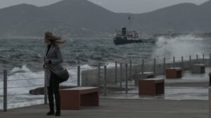
Severe weather is expected from Saturday night through Sunday across parts of western and northern Greece, with storms, gale-force winds and the transport of African dust, according to the Hellenic National Meteorological Service.
Meteorologist Thodoris Kolydas warns that, on top of the already burdened conditions caused by African dust, a new wave of intense weather phenomena is forecast to affect areas where the ground is already saturated from recent rainfall. This significantly increases the risk of localized flooding, even if storms are short-lived but intense.
ΕΚΤΑΚΤΟ ΔΕΛΤΙΟ ΕΠΙΔΕΙΝΩΣΗΣ
— Theodoros Kolydas (@KolydasT) February 14, 2026
⚠️Στο ήδη επιβαρυμένο σκηνικό του καιρού με τη μεταφορά αφρικανικής σκόνης, έρχεται να προστεθεί και το Έκτακτο Δελτίο Επιδείνωσης Καιρού της Εθνικής Μετεωρολογικής Υπηρεσίας (ΕΜΥ), το οποίο εστιάζει σε περιοχές με αυξημένο κίνδυνο εκδήλωσης έντονων… pic.twitter.com/cB50EfpDiT
Areas Most Affected
- Corfu and Paxoi: From Saturday night until Sunday morning.
- Epirus: From overnight hours through midday Sunday.
- Eastern Macedonia and Thrace: From late morning Sunday until late afternoon.
At the same time, very strong to gale-force southerly winds are expected. Winds will reach 7–8 Beaufort in the Ionian Sea on Saturday night, while on Sunday they will strengthen in the Aegean Sea to 8 Beaufort, locally up to 9 Beaufort in eastern parts.
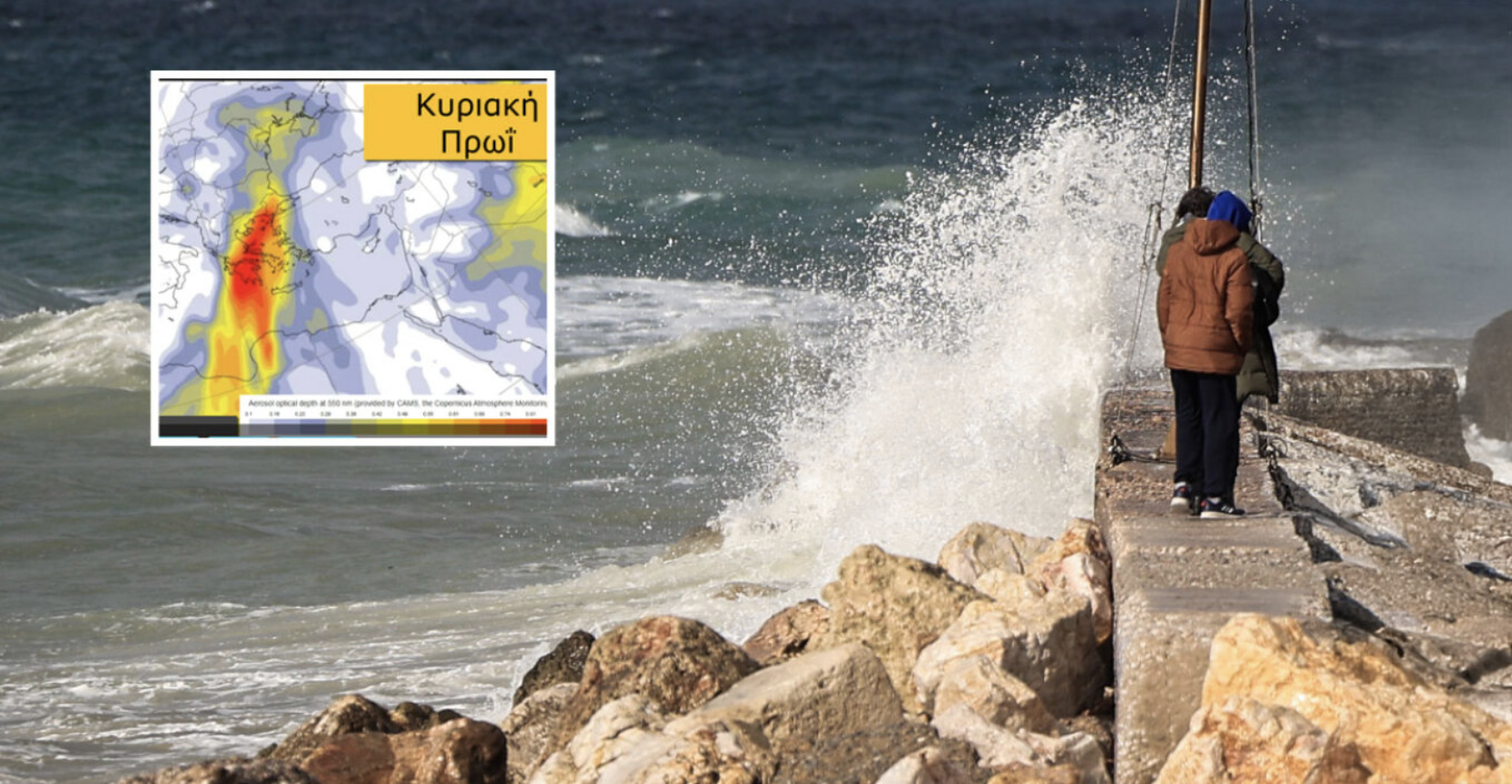
African Dust Transport
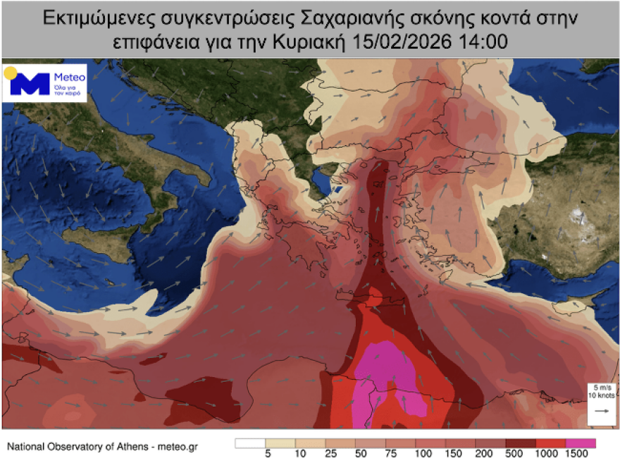
Weather conditions also favor significant transport of African dust, mainly affecting eastern and southern Greece. Higher concentrations are expected in the Peloponnese, Crete, eastern Central Greece (including Attica), the Cyclades and Evia.
EMY Emergency Weather Bulletin
The emergency bulletin issued by the Hellenic National Meteorological Service forecasts strong rain and thunderstorms from Saturday night through Sunday afternoon in western and northern Greece:
- Corfu–Paxoi: From Saturday evening (14/02/2026) to Sunday morning (15/02/2026).
- Epirus: From overnight hours until midday Sunday (15/02/2026).
- Eastern Macedonia & Thrace: From late morning to late afternoon on Sunday (15/02/2026).
Strong to gale-force southerly winds are expected in the Ionian Sea (7–8 Beaufort) on Saturday night and in the Aegean Sea on Sunday (8 Beaufort, locally 9 in eastern areas).
The bulletin will be updated within 12 hours.
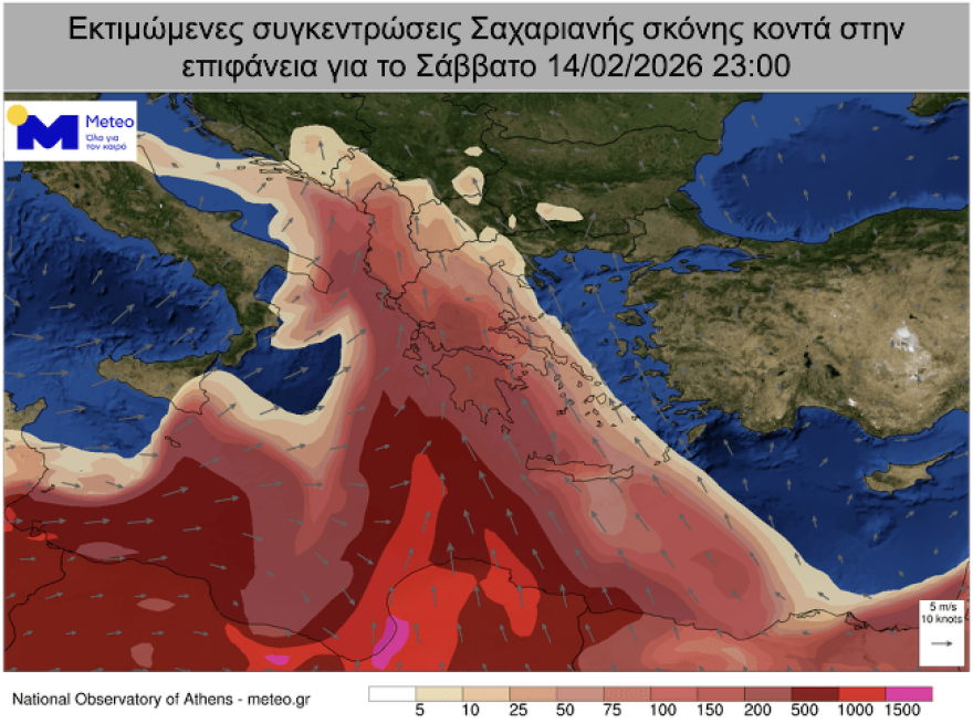
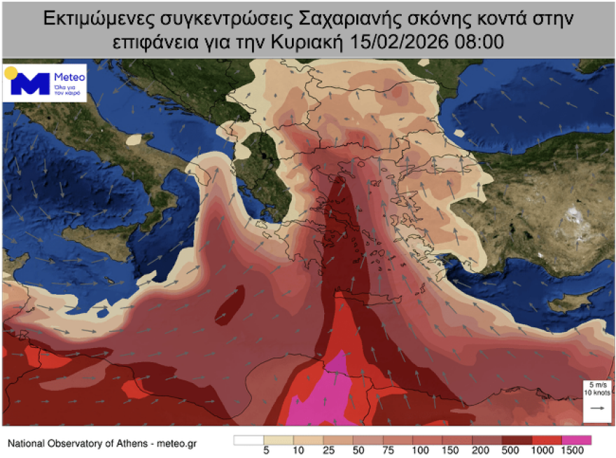
Saharan Dust: Sunday Peak
According to forecast data from the National Observatory of Athens, Saharan dust transport will affect Greece throughout the weekend, peaking on Sunday, February 15. The highest concentrations are expected in southern Greece—particularly Crete, the Peloponnese and the southern Aegean—with notable increases also forecast in parts of northern Greece.
Civil Protection Recommendations
The General Secretariat for Civil Protection urges citizens to remain vigilant and take precautionary measures. Relevant state services, regions and municipalities have been placed on heightened alert, while the Fire Service has activated its operational plan for flood risk management.
Key advice to citizens includes:
- Secure objects that could be displaced by strong winds.
- Ensure gutters and drains are clear and functioning.
- Avoid crossing streams or flooded roads, on foot or by vehicle.
- Refrain from outdoor work and marine or coastal activities during severe weather.
- Seek immediate shelter during hailstorms or lightning activity.
- Avoid standing near large trees, power lines, signs or unstable structures.
- Follow instructions from local authorities and traffic police.
Citizens are advised to stay informed through regular weather bulletins issued by the Hellenic National Meteorological Service and via its official website.
Ask me anything
Explore related questions