February 18, 2026 — Greece is battling strong to storm-force winds today, with gusts reaching up to 10 Beaufort in many regions, causing widespread disruption and damage. Meteorologists warn of a brief respite on Thursday, but another storm system is set to bring rain and thunderstorms starting Friday, followed by a significant drop in temperatures over the weekend.
Stormy Wednesday: Winds, Floods, and Damage
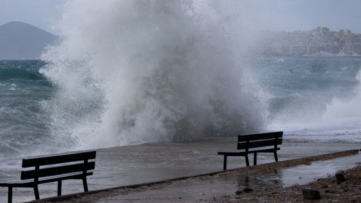
Greece is experiencing one of its most intense weather events of the season today, as powerful winds—reaching up to 10 Beaufort—sweep across the Ionian Sea, Crete, and the Aegean. The National Meteorological Service recorded a wind gust of 110 km/h in Corfu, equivalent to 11 Beaufort, which led to fallen trees and minor infrastructure damage in several areas.

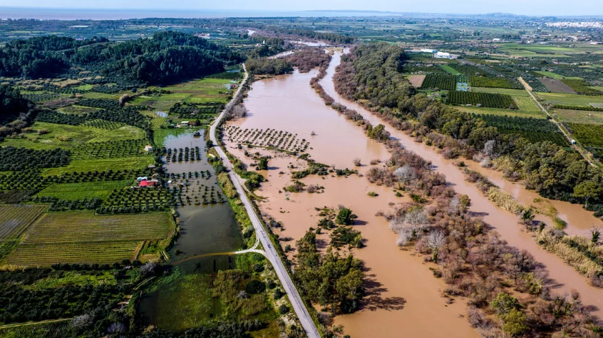
Meanwhile, the western Peloponnese is grappling with severe flooding after the Pineios River overflowed, submerging farmland and roads in Ilia. Emergency crews are working to clear debris and drain floodwaters, but the situation remains critical in several villages. Similar flooding has been reported along the Alfeios River.
Today’s Weather Breakdown:
- Winds: Storm-force (9-10 Beaufort) in the Ionian, western mainland, Crete, Cyclades, and southeastern Peloponnese; gradually weakening in the east.
- Temperatures: Ranging from 2°C in northern Greece to 16°C in Crete.
- Conditions: Mostly sunny with scattered clouds, local rain in Thrace, and temporary storms in the eastern Aegean and Dodecanese.

Thursday Respite, Friday Storms
According to meteorologist Theodoros Kolydas, the worst of today’s storm will subside by Thursday, with winds easing and skies clearing across most of the country. “The intense phenomena are now limited to Thrace, the eastern Aegean, and the Dodecanese,” Kolydas noted, adding that Thursday will be the calmest day of the week, with temperatures rising to 15-18°C in most regions.
However, the relief will be short-lived. A new low-pressure system is expected to move in from the west on Friday, bringing widespread rain and thunderstorms. “From Friday afternoon, we’ll see a return of unstable weather, with strong southerly winds and local storms, especially in the northwest and northeastern regions,” Kolydas warned.

Weekend Chill: Snow and Dropping Temperatures
The weekend will bring a marked shift in weather patterns, with a cold front sweeping across the country. On Saturday, northern winds will dominate, causing temperatures to plummet by up to 6°C. Snow is expected in the mountains of Epirus, Macedonia, and possibly central Greece.
Meteorologist Giannis Kallianos described the weekend outlook as “unstable on Friday and Saturday, with Sunday being the coldest day.” He added that Clean Monday (February 23) should be relatively mild, with maximum temperatures around 14°C and only local showers.
Weekend Forecast:
- Saturday: Increased cloudiness, local rain, and scattered storms in the Aegean; snow in mountainous and semi-mountainous areas.
- Sunday: Local rain in central and southern regions; snow in Thessaly, eastern central Greece, and the Peloponnese.
- Temperatures: Continuing to drop, especially in the east.
Clean Monday: A Mild Start to Lent
Greeks can expect a relatively calm Clean Monday, with partly cloudy skies and local showers, mainly in the east. Temperatures will hover around 14°C, offering a mild start to the Lenten season.
Impact and Response
The severe weather has already caused significant disruption. In Corfu, fallen trees blocked roads and damaged property, though no injuries were reported. In Ilia, the overflowing Pineios River has inundated farmland and homes, prompting a swift response from local authorities and emergency services.
As the country braces for more storms and a sharp drop in temperatures, meteorologists advise caution, especially in flood-prone and mountainous areas.
Ask me anything
Explore related questions


