
Changes in weather begin today as a field of low barometric pressure will affect the country with bad weather meaning rain and thunderstorms, strong to stormy southern winds in the Aegean, significant drop in temperature, and increased concentrations of dust in the atmosphere.
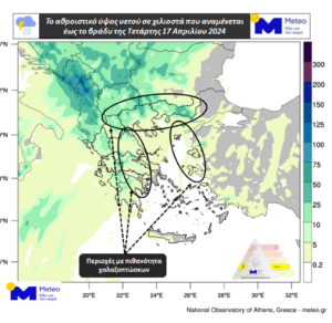
Rain and scattered thunderstorms are expected this afternoon in mainland Greece, the Ionian Islands, Crete, and the Northern and Eastern Aegean. Possibility of hail mainly in northern, eastern, and southeastern mainland Greece as well as in the Eastern and Northern Aegean. Thursday 18/04 nighttime this weather will seen in Thrace, the eastern parts of the Aegean, and in the mountain areas of western and southern mainland Greece things will be milder.
Below Image 1 indicates the amount of rainfall expected for Wednesday 17/04 in the evening.
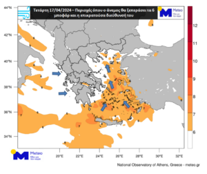
South winds in the Aegean Sea will gradually strengthen, reaching 7-8 Beaufort scale. On Thursday 18/04 during nighttime winds be west at 6-7 Beaufort. In the Ionian Sea, winds are not expected to exceed 4 Beaufort which should till Wednesday noon 17/04, when these winds from the west will be between 5-6 Beaufort.
The map below shows areas where winds will exceed 6 Beaufort for Wednesday 17/04.
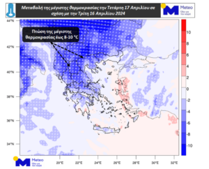
Temperatures will drop, and in northern mainland areas will reach 8 to 10°C. The rest of the mainland will range from 4-8°C, reaching levels normal for the season.
The below map shows expected lows in temperature for Wednesday 17/04.
Dust concentrations will increase and in some areas, mud showers may occur.
Kolydas: Double Disturbance Ahead
Two disturbances will affect our country in the coming days, according to the director of the National Meteorological Service, Thodoris Kolydas.
“Although this weather forecast will not be extreme, it is good to be cautious, especially for those in the western and northern parts of the country,” he said in a post.
Analytically from EMY:
Emphasised was the first disturbance that will occur between Wednesday-Thursday and the second Friday-Saturday. “Although high values for rainfall are not recorded relative attention is needed in areas where the shades of orange are more intense.”
Snowfall will be limited on Friday-Saturday, mainly at high altitudes in the Central and Northern regions…'”
Today’s Weather
Scattered showers and thunderstorms are expected initially in the northwest and west mainland, in the Peloponnese, and in the Ionian Sea, gradually expanding to the rest of the mainland, Crete, and the Northern and Eastern Aegean until noon. Possibility of hailstorms (mainly small) mainly exists in the northern, eastern, and southeastern mainland, as well as in the Northern and Eastern Aegean. Dust concentrations in the atmosphere will increase and there will be local mudslides
Temperature in Western Macedonia will range from 9 -16 degrees Celsius, in the rest of Macedonia and Thrace from 14-25, in Epirus from 10-21, in Thessaly from 16-25, in Central Greece and the Peloponnese from 12-26, in the Ionian islands from 14-20, in the islands of the Northern and Eastern Aegean from 14 -27, in the Cyclades from 17-24, in the Dodecanese from 17 -24, and in Crete from 17 -27 degrees Celsius.
Winds in the Aegean will initially be coming in from southern directions at 4-6 Beaufort, but will gradually strengthen from the morning, blowing from southern directions at 6-8 Beaufort. In the evening, they will shift to western directions at 5-7 Beaufort. In the Ionian Sea, winds will initially blow from variable directions at 2-4 Beaufort, but from noon onwards, they will be coming in from the west at 3-5 Beaufort, locally reaching 6 Beaufort.
FORECAST FOR THURSDAY 18-04-2024:
Clouds are expected to temporarily increase with local showers and mainly in the northeast in the western, northern, and eastern island areas. In the rest of the country, the weather will be mostly clear with a few clouds, occasionally increasing mainly in the afternoon and evening hours. Concentrations of African dust will gradually be limited to the east. Winds will blow from the west-southwest at 4 to 6 Beaufort, locally reaching 7 Beaufort in the southern Aegean Sea. Temperatures will experience a slight decrease in the west, central, and north, reaching 18-21 degrees Celsius in the northwest and 22-24 degrees Celsius in the rest of mainland and the island region.
FORECAST FOR FRIDAY 19-04-2024:
Initially, clouds with rain and partial thunderstorms are expected in the west, north, and eastern island regions. Phenomena will gradually intensify and expand to the rest of the country, where they may be temporarily strong, initially in the west and in the evening in the east, with a parallel decrease in the west. Weak snowfall will occur in the northwestern mountainous regions. Winds will blow from the west-southwest at 4 to 6 Beaufort, locally reaching 7 Beaufort in the seas. In the evening, they will turn to west-northwest with the same intensity. There will be a slight further decrease in temperature in the west and north.
FORECAST FOR SATURDAY 20-04-2024:
Clouds with rain and scattered thunderstorms are expected initially in the east, a possibly strong in the morning with gradual weakening. In the rest of the country, there will be clouds with local showers and partial thunderstorms that will be temporary. There will be snowfall in northern mainland mountain areas. Winds will be coming in from the west-northwest at 4-6 Beaufort, reaching 7 Beaufort, with a possibility of 8 Beaufort in the seas weakening in the evening. There will be no significant temperature change.
FORECAST FOR SUNDAY 21-04-2024:
Periodically increased clouds with local showers and scattered thunderstorms are expected in the Ionian, mainland, and eastern island regions. In the evening, phenomena will be limited to the northeast. Mild snowfall in northern mainland mountain areas. Winds will blow from the west-southwest at 4-6 Beaufort, locally reaching 7 Beaufort in the Aegean Sea. Gradually, in the west, central, and north, winds will turn to west-northwest and weaken. There will be a slight temperature rise.
Ask me anything
Explore related questions