Greece is preparing to face the first heatwave of this summer, with meteorologists warning of temperatures that will exceed even 42°C in the coming days.
According to forecasts, the heatwave will last for three to four days, with the peak expected on Thursday and Friday.
Kolyadas: What is a heatwave and where will temperatures reach in the coming days
In a post, Theodoros Kolyadas explained what a heatwave is and where temperatures will reach in the coming days.
“WHAT IS A HEATWAVE AND WHERE WILL TEMPERATURES REACH IN THE COMING DAYS – HOW TO READ THE METEOGRAMS
Although there is no universal definition of a heatwave in international terminology, it is noted that the criteria for defining it vary depending on the geographical location and the climatic conditions of an area. For example, while temperatures around 35°C are considered to approach ‘heatwave’ levels in Scandinavian countries, they are considered normal for our region. On the other hand, temperatures around 40°C, while considered normal for residents of the Sahara or Saudi Arabia, are regarded as ‘heatwave’ levels in our country.
The article provides a brief analysis of the forecast data using Athens as an example, though it can apply to any city.”
A heatwave of moderate intensity and relatively short duration – Friday will be the hottest day, says Kallianos
From today, Wednesday, June 25 through Friday, June 27, we will experience unseasonably high temperatures, about 7-8°C above normal.
The peak will come on Friday
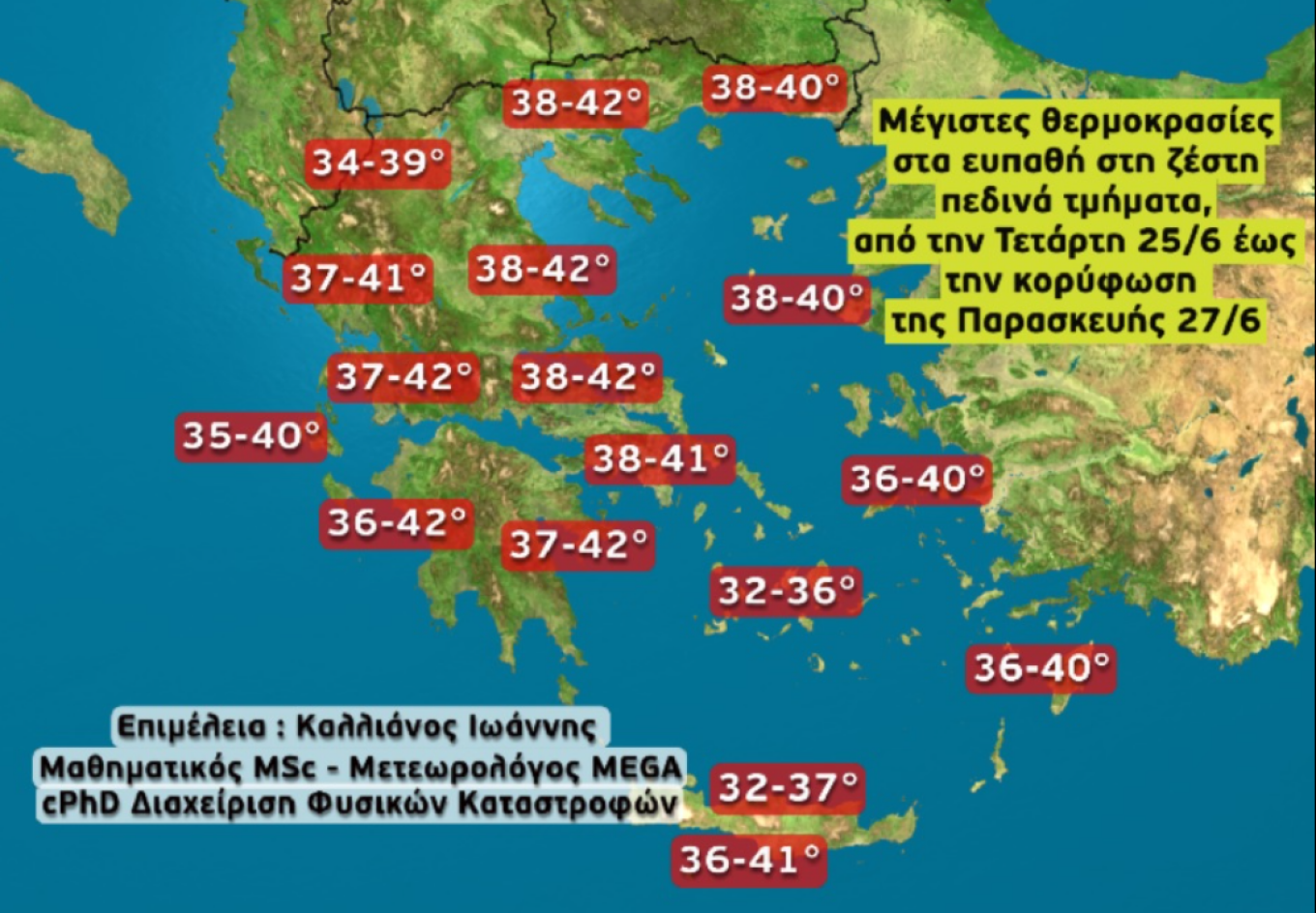
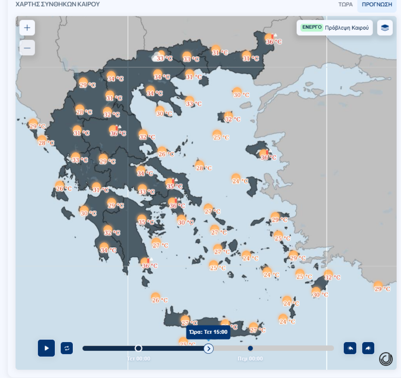
On Friday, June 27, according to the latest forecast data, very high temperatures will be recorded, affecting most of the country. However, the atmosphere will be clear of dust thanks to northerly winds, and on Friday, the last day of the heatwave, there will be local showers or storms in Northern Greece from midday onward. A map is also presented showing the progression of maximum temperatures in various heat-sensitive regions of the country from Wednesday (milder day) to Friday (peak of the heatwave).
Where temperatures will reach in the 5 largest cities of the country
ATHENS:
Wednesday: 38°C
Thursday: 39-40°C
Friday: 40-41°C
Saturday: 37-38°C
Sunday: 34°C
THESSALONIKI:
Wednesday: 37-38°C
Thursday: 38°C
Friday: 38-39°C
Saturday: 35-36°C
Sunday: 35°C
PATRAS:
Wednesday: 35°C
Thursday: 36-37°C
Friday: 37-38°C
Saturday: 39-40°C
Sunday: 37°C
HERAKLION:
Wednesday: 32°C
Thursday: 34-35°C
Friday: 34-35°C
Saturday: 34-35°C
Sunday: 30°C
LARISSA:
Wednesday: 38°C
Thursday: 40-41°C
Friday: 41-42°C
Saturday: 38°C
Sunday: 36°C
Note: These temperatures are indicative and represent average values. Variations are possible as we move further into the forecast period. It would be a surprise if temperatures hit 43°C anywhere – if so, it will be very localized.
Which areas will feel the heat most intensely
The areas that will “boil” are:
- The interior of Central Macedonia
- The interior of Thessaly
- Western Central Greece
- Western Peloponnese and further east
What Panagiotis Giannopoulos predicts
The meteorologist speaks of a gradual rise in temperatures, with Friday expected to be the hottest day, followed by several days of very strong northerly winds.
On Friday, even in Athens, the thermometer will reach 40°C (in the city center and the western parts of the city).
Obviously, in inland areas, far from the sea, temperatures will locally exceed 40°C. Then, on Saturday, the mercury will drop slightly and even further on Sunday.
The northerly wind will not stop in the Aegean — today and tomorrow at 6 Beaufort, weakening slightly on Thursday and Friday. From Saturday, winds will strengthen to 7 Beaufort, on Sunday locally 8 Beaufort, and will remain strong until next Wednesday.
Maximum temperature exceeded 37°C yesterday
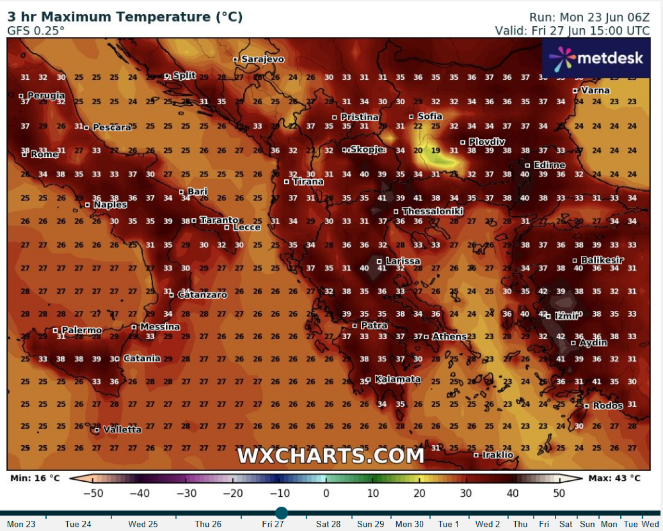
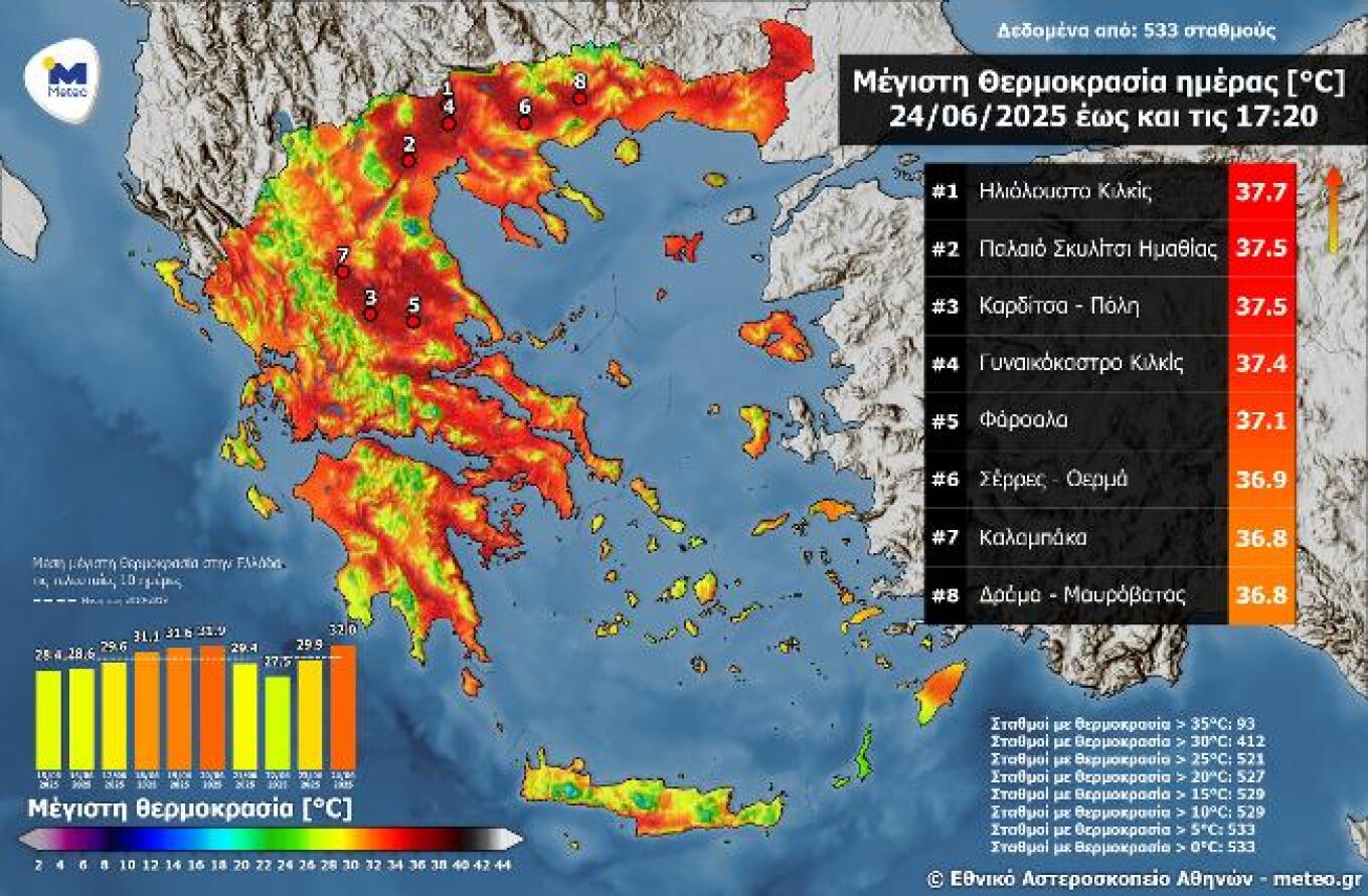
On Tuesday 24/06, temperatures rose, with the maximum exceeding 37°C. The highest among all active meteorological stations of the National Observatory of Athens / meteo.gr network was recorded at the sunny Kilkis station (37.7°C), followed by the stations in Karditsa city and Palaios Skilitsios, Imathia (37.5°C). The map in the following image shows the distribution of maximum temperatures across the country according to the automatic meteorological stations of the National Observatory of Athens / meteo.gr.
As shown by the related data presented in the image, temperatures exceeded 30°C at 412 out of the 533 currently active stations (~77%), and 25°C at 521 stations (~98%). The average maximum temperature was 32.0°C, which is 2.1°C higher than that of 23/06 (29.9°C).
Today’s weather
Sunshine is expected, with only some local clouds developing over the mainland mountains at noon and in the afternoon. Slightly increased dust concentrations in the east, north, and northeastern mainland and the Aegean.
Temperatures:
- Western Macedonia: 15 to 33°C
- The rest of Macedonia, Thrace, Thessaly: 19 to 39°C
- Epirus: 19 to 35°C
- Central Greece and Peloponnese: 17 to 38°C
- Ionian Islands: 19 to 36°C
- North and East Aegean Islands: 19 to 38°C
- Cyclades: 20 to 34°C
- Dodecanese: 22 to 33°C
- Crete: 21 to 35°C
Winds:
- Central and North Aegean: north winds 3–5 Beaufort
- South Aegean: west to northwest winds 3–5 Beaufort
- Ionian: northwest winds 2–4 Beaufort
In Attica: Sunny. North winds 2–4 Beaufort. Slightly increased dust concentrations. Temperature in central Athens: 25 to 38°C.
In Thessaloniki: Sunny. Variable winds up to 3 Beaufort. Slightly increased dust concentrations. Temperature in central Thessaloniki: 25 to 37°C.
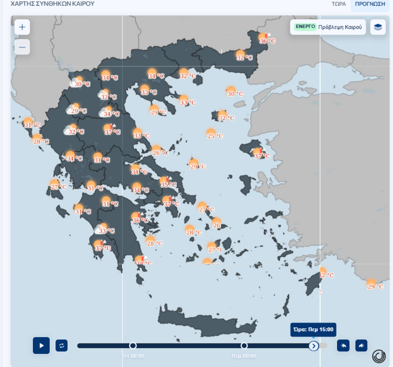
Thursday 26 June weather
Generally clear weather across the country with few temporary clouds over central and northern mainland mountains at noon and in the afternoon.
Winds: North 3–5 Beaufort, locally up to 6 in central and southern Aegean.
Temperature: Slight further rise. Will reach 38–40°C in the mainland, 36–38°C in Ionian islands, eastern Aegean, southern Crete, and 33–35°C elsewhere in island areas.
Friday 27 June weather
Generally clear weather across the country. In the afternoon, local clouds will develop over the mainland, with local showers or short thunderstorms in the north.
Winds: North 3–5 Beaufort, locally 6 in the Aegean.
Temperature: Will remain at high levels, reaching 40–41°C in parts of the mainland.
Saturday 28 June weather
Generally clear weather with some clouds at noon and afternoon over mainland mountains, where local showers may occur. At night, clouds will develop in Thrace, southern Macedonia, and the Sporades.
Winds: North 4–5 Beaufort, 6–7 in the seas.
Temperature: Will drop by 2–3°C.
Sunday 29 June weather
In Thrace, eastern Thessaly, Sporades, Euboea, and eastern Central Greece, passing clouds with some local rain. Elsewhere generally clear.
Winds:
- West initially east 4–6 Beaufort, turning north later at the same intensity
- East: North winds 4–6 Beaufort, 7 locally 8 in the Aegean
Temperature: Will drop further.
Ask me anything
Explore related questions