
The wave of bad weather that swept across several parts of Greece over the past 48 hours is gradually easing, now moving toward the East Aegean islands. However, meteorologists warn that a new spell of severe weather is expected to return from Monday.
“From Sunday evening, a new wave of bad weather will move in from the Adriatic Sea and will be felt across the country from Monday to Tuesday,” said Open TV meteorologist Klearchos Marousakis. “It will bring rain, local thunderstorms, even in Attica, and will sweep the country from northwest to southeast between Monday and Wednesday.”
According to Alpha’s meteorologist, Giorgos Tsatrafyllias, after a relatively mild weekend with a small temperature rise, another autumn system will bring heavy rains, storms, lower temperatures, and strong northerly winds from Monday until Wednesday. In a post on social media, he pointed out that from Sunday evening, a new barometric low will move in from the northwest, spreading rain across most of the country until midweek. The heaviest rainfall is expected in Eastern Macedonia, Thrace, the North and East Aegean, and the Dodecanese.
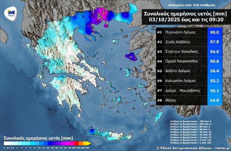
Heavy rainfall recorded in Central and Eastern Macedonia
On Friday morning, the northern mainland and islands of the North and East Aegean were hit hardest. Data from the National Observatory of Athens (meteo.gr) show that the highest rainfall up to 09:20 Friday was recorded in Paranesti, Drama (90 mm), while all eight of the stations with the highest levels were located in Central and Eastern Macedonia.
Today’s Forecast (Friday, October 3)
- Clouds with scattered showers in Thrace, North and East Aegean, Dodecanese, Crete, Ionian, Sterea, and Peloponnese. Phenomena will weaken and stop by midday.
- Temperatures:
- Western Macedonia 1–14°C, Rest of Macedonia 7–17°C, Thrace 10–17°C, Thessaly 7–20°C, Epirus 5–17°C, Sterea/Peloponnese 9–21°C, Ionian 10–18°C, North/East Aegean 13–20°C, Cyclades 16–23°C, Dodecanese 19–23°C, Crete 13–24°C.
- Winds: Aegean SW–W 3–6 Beaufort; Ionian NW 4–6 Beaufort (weakening through the day).
- Attica: Clouds at times, 14–20°C. Winds W 2–4 Bft.
- Thessaloniki: Sunshine with local clouds, 8–17°C. Winds N 2–4 Bft.
Sunday, October 5
- Western Greece: Increasing clouds, chance of light rain.
- Elsewhere: Mostly clear; local clouds in Crete, East Aegean, and Dodecanese with brief showers possible.
- Evening: Heavy rain and thunderstorms in the northern Ionian.
- Winds: Westerly 3–4 Bft, up to 5 Bft in southern seas. In the northern Ionian turning SSW up to 5 Bft.
- Temperatures: Slight rise — North 19–21°C (16–18°C in NW inland), rest of country 22–23°C, up to 24–25°C in Dodecanese, Cyclades, Crete.
Monday, October 6
- Ionian, Epirus, Western Central Greece: Cloudy with showers and storms from early in the day.
- Rest of the country: Rain and storms spreading eastward through the day.
- Improvement: From late afternoon in the west, but persistent elsewhere.
- Winds: South 4–5 Bft, turning north later in the west and north.
- Temperatures: Stable.
Ask me anything
Explore related questions