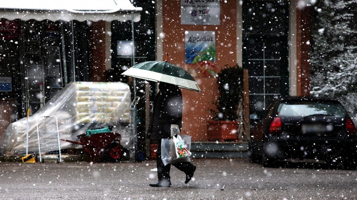
A significant change in the weather begins today, Sunday 11 January, with a noticeable drop in temperature that in many areas will exceed 10 degrees Celsius, according to the latest forecast data from the National Observatory of Athens / meteo.gr. This comes after Saturday’s gale-force southerly winds and heavy rainfall caused serious damage in several parts of the country, notably Alexandroupoli, Messolonghi, Nafplio, and Tinos.
Sharp temperature drop and frost
The temperature drop will initially be felt in northern Greece and will gradually spread to the rest of the country. On Monday 12 and Tuesday 13 January, temperatures will remain low, while frost is expected during the morning hours, with values below 0°C even in lowland areas of central and northern mainland Greece.
According to forecast data, in many regions maximum temperatures will remain in single digits, giving the scene clearly wintry characteristics.
Meteo.gr data show the descent of cold air masses over Greece.
Kolydas: “Clearly wintry conditions”
In a post, meteorologist Thodoris Kolydas points out that the weather change beginning today marks an abrupt temperature drop, which will initially affect the north and then the entire country.
As he notes, in many areas of central and northern mainland Greece, maximum temperatures will remain in single digits, while overall the drop is estimated to reach 10 degrees Celsius.
In Attica, snowfall will occur in the northern and eastern parts—Parnitha and Penteli—in mountainous and semi-mountainous areas during the late hours of Sunday and the early hours of Monday. “It will certainly snow on Parnitha and Penteli and in semi-mountainous areas. Beyond that, we need to see whether some snow will fall without accumulating based on today’s data. Whether it will snow in the northern suburbs cannot be said at this point,” the meteorologist stated.
Snow will fall in Epirus on Sunday, and from the afternoon onward “the Aegean comes into play,” with snowfall extending southward “from Halkidiki, to the Sporades, reaching as far as Evia.” According to Mr. Kolydas, the peak of snowfall is expected from Sunday afternoon and mainly at night, in Evia, Fthiotida, and the Sporades.
Damage from strong winds
Gale-force southerly winds combined with rainfall caused serious damage on Saturday in Alexandroupoli and Messolonghi. In Alexandroupoli, wind gusts reached 140 km/h, resulting in damage to shops and homes, uprooted trees, and boats being pushed ashore.
In Messolonghi, a tornado struck, causing damage to property, homes, shops, and even schools, according to the city’s Deputy Mayor for Daily Life, Environment, and Recycling, Christos Vourvachis. The phenomenon hit from the port area to Zesti, with winds uprooting trees, tearing off roofs, and dismantling large metal structures.
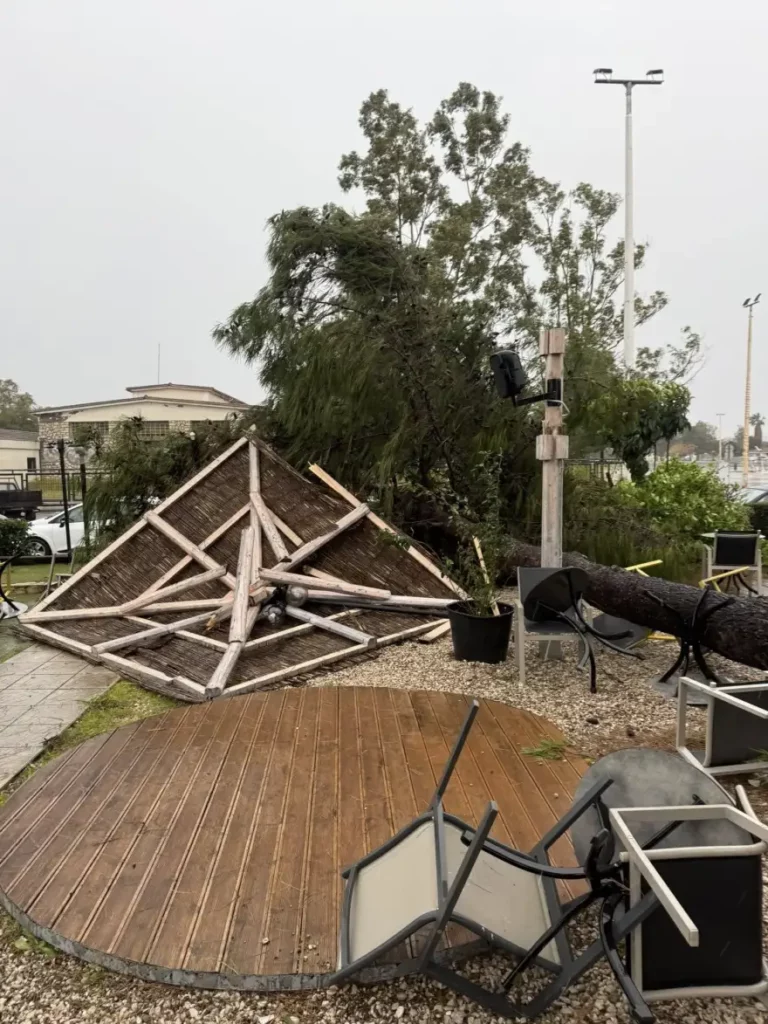
Residents and shop owners in Nafplio faced a difficult situation as gale-force winds caused heavy wave action and seawater flooded the old town. Roads were flooded and traffic was halted on Amalias and Syngrou streets.
Similar scenes were recorded in Rio, where severe weather and strong southwesterly winds caused sea levels to rise and water to overflow onto the coastal road. The area resembled scenes of… Venice, with water covering parts of the roadway and creating serious traffic problems.
Gale-force winds in the Antirrio area resulted in flooding on the western pier roads.
The strong southerly winds also caused problems in coastal shipping on Saturday, while wave action in the port of Tinos led to seawater flooding inland.
At the outer port of Tinos, near the old “Mariner” building, the sea swept cars away, causing collisions, according to tinosnews.gr.
It is recalled that the sailing ban remains in effect due to adverse weather conditions. The situation is expected to be reassessed today, when further updates will be issued.
Hellenic National Meteorological Service (EMY): Today’s weather
Warnings: Locally strong rains and thunderstorms are possible in the Dodecanese. During the morning hours, gale-force west–southwesterly winds up to 8 Beaufort in Crete, the Cyclades, and the Dodecanese, and during the evening hours gale-force north–northwesterly winds up to 8 Beaufort locally in central Macedonia.
Increased cloudiness with local rains in western areas and the eastern Aegean, with scattered thunderstorms, possibly locally strong in the Dodecanese. Snowfall will occur in mountainous and northern semi-mountainous areas and, from evening hours, in parts of northeastern Greece at lower altitudes.
Winds will blow in the south from westerly directions at 5–7 Beaufort and locally up to 8 Beaufort over the seas during the morning. In the north, winds will blow from northerly directions at 4–6 Beaufort, gradually strengthening to 5–7 and in the northern Aegean locally up to 8 Beaufort in the evening.
Temperatures will drop noticeably in the north and will not exceed 6–8°C, while in the rest of the country they will reach 9–15°C, and in the Cyclades, Crete, and the Dodecanese 16–18°C. Frost will occur in central and northern mainland areas.
Detailed forecast
ATTICA
Weather: Periods of increased cloudiness with local rain, mainly around midday and in the afternoon.
Winds: West–southwesterly 4–6 Beaufort, turning north–northwesterly with the same intensity from the afternoon.
Temperature: 5 to 15°C.
THESSALONIKI
Weather: Cloudy with local rain and snowfall in mountainous and semi-mountainous areas, gradually improving from the afternoon.
Winds: North–northwesterly 4–6 Beaufort, locally 7 from midday and up to 8 Beaufort in the evening.
Temperature: 0 to 8°C.
MACEDONIA, THRACE
Weather: Cloudy with local rain and mainly isolated thunderstorms in coastal areas. Snowfall in mountainous and semi-mountainous areas and, from evening hours, in low-altitude areas of eastern Macedonia and Thrace. Gradual improvement in western and central Macedonia during the evening.
Winds: Northerly 4–6 Beaufort, locally 7 from midday and up to 8 Beaufort in parts of central Macedonia in the evening.
Temperature: 0 to 8°C; in western Macedonia 4–5 degrees lower.
IONIAN ISLANDS, EPIRUS, WESTERN CENTRAL GREECE, WESTERN PELOPONNESE
Weather: Cloudy with local rain and, mainly in the morning hours, scattered thunderstorms in the Ionian Islands, western Central Greece, and western Peloponnese. Snowfall in mountainous mainland areas and semi-mountainous regions of Epirus. Gradual improvement in most areas during the evening.
Winds: West–northwesterly 4–6 Beaufort, locally 7 in the Ionian, and up to 8 Beaufort in southern areas during the morning.
Temperature: 2 to 14°C; 4–5 degrees lower inland in Epirus.
THESSALY, EASTERN CENTRAL GREECE, EVIA, EASTERN PELOPONNESE
Weather: Periods of increased cloudiness with local rain and isolated thunderstorms mainly around midday and in the afternoon. Snowfall in mountainous mainland areas and the mountains of Evia.
Winds: West–southwesterly 4–6 Beaufort, locally 7–8 in the south; gradually shifting from the north to north–northwesterly 4–6 Beaufort, locally up to 7 in the north.
Temperature: 3 to 15°C; 3–4 degrees lower in northern areas.
CYCLADES, CRETE
Weather: Periods of increased cloudiness with local rain and scattered thunderstorms.
Winds: West–southwesterly 6–8 Beaufort, turning west–northwesterly 5–7 Beaufort from the afternoon.
Temperature: 10 to 18°C.
EAST AEGEAN ISLANDS – DODECANESE
Weather: Cloudy with rain and scattered thunderstorms, possibly locally strong in the Dodecanese.
Winds: In the south, west–southwesterly 5–7 Beaufort, locally up to 8 in the morning, gradually turning west–northwesterly. In the north, west–southwesterly 5–7 Beaufort, quickly turning north–northeasterly and strengthening to up to 8 Beaufort in the evening.
Temperature: 8 to 18°C; 2–3 degrees lower in the north.
Weather on Monday, 12 January
In the Ionian, few temporary clouds until midday. In western Macedonia, Epirus, western Central Greece, and western Peloponnese, cloudiness with local rain or sleet and snowfall in mountainous and semi-mountainous areas, clearing to mostly fair weather after midday.
In Thrace, central and eastern Macedonia, the northeastern Aegean islands, the Sporades, Thessaly, eastern Central Greece, Evia, and eastern Peloponnese: sleet, isolated thunderstorms in coastal areas, and temporary snowfall in mountainous and semi-mountainous regions (above approximately 300 m). In Thrace and eastern Macedonia, snowfall will temporarily occur even in lowland areas (above approximately 100 m). From late afternoon, phenomena will cease in most areas. In the Cyclades, Crete, and the Dodecanese, local rain, isolated thunderstorms, and snowfall in mountainous areas of Crete and the Cyclades.
Winds will blow from northerly directions at 5–6 Beaufort and over the seas 7–8 Beaufort.
Temperatures will drop further nationwide. Minimum temperatures in the north will range from -3 to -5°C, in the northwest from -6 to -10°C, and in central mainland areas from -3 to 0°C. Maximum temperatures in the north will not exceed 5°C, in eastern mainland areas 6–8°C, while in western areas, the Cyclades, and Crete they will reach 9–11°C, and in the Dodecanese 11–13°C.
Frost will occur in mainland areas, being widespread and locally severe in the north.
Weather on Tuesday, 13 January
In Crete and the southern Aegean, cloudiness with local rain, light snowfall in mountainous areas, and rapid improvement. In the rest of the country, generally fair weather with a few local clouds.
Winds will blow from northerly directions at 4–6 Beaufort and in the southern Aegean 7–8 Beaufort, gradually weakening from the north. Temperatures will rise slightly in terms of daytime highs. Frost will occur in mainland areas, locally severe in central and northern regions.
Weather on Wednesday, 14 January
Generally fair weather with local cloudiness. Winds in the south will be northwesterly 4–5 Beaufort, while elsewhere variable at 2–4 Beaufort. Temperatures will rise, though localized frost will occur in mainland areas early in the morning.
Weather on Thursday, 15 January
Generally fair weather with local cloudiness. Visibility will be locally limited during morning and evening hours. Winds in eastern areas will blow from northerly directions at 3–5 Beaufort, while in western areas they will be variable at 2–4 Beaufort. Temperatures will not change significantly, though localized frost will occur early in the morning in northwestern mainland areas.
Ask me anything
Explore related questions