
Five regions, including Attica, are on red alert ahead of the severe weather phenomena expected tomorrow, Wednesday.
Rainfall will begin early on Wednesday, but conditions are expected to worsen gradually. In Attica in particular, forecasts indicate heavy rain and thunderstorms from midday onward. The phenomenon is classified as Category 5, meaning an extreme weather event.
Meanwhile, authorities are mobilizing in preparation for the weather conditions. Tomorrow, Wednesday, all primary and secondary schools in Attica will remain closed, following a decision by the regional administration.
Areas expected to receive large volumes of rain
A deep low-pressure system moving from the Gulf of Sirte toward the northeast will bring a significant deterioration in weather conditions on Wednesday, with heavy rain and thunderstorms, as well as snowfall even at low altitudes, according to meteo.gr.
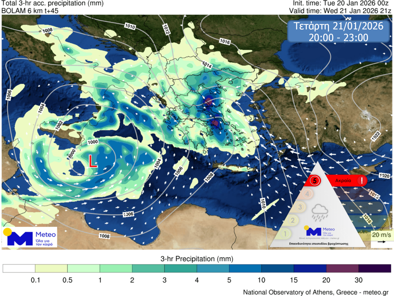
Based on forecast data from the National Observatory of Athens / Meteo.gr, during Wednesday 21/01, rain and thunderstorms will be locally intense:
- from midday in eastern and southern Peloponnese,
- from the afternoon in eastern Central Greece (including Attica), Thessaly, Evia and the Sporades,
- and from the evening in the Cyclades.
In the prefecture of Attica and in the city of Athens, rainfall is expected from early morning, intensifying in the afternoon, when heavy rain and thunderstorms are likely to occur.
According to the Rainfall Potential Index (RPI) classification applied by the Meteo unit of the National Observatory of Athens, the rainfall event on Wednesday 21/01 is categorized as Category 5 (Extreme).
In addition, the following should be taken into account regarding the severe weather:
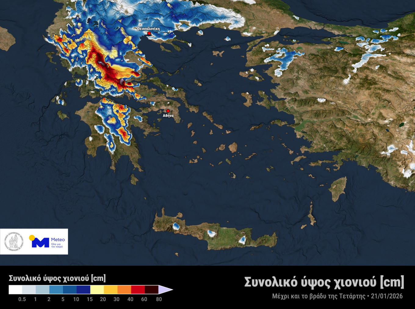
- Heavy snowfall in mountainous and semi-mountainous areas of mainland Greece and the Northern Aegean, as well as in lower-altitude areas of Western and Central Macedonia, Thessaly, and temporarily Eastern Macedonia and Thrace.
- Large volumes of rainfall expected mainly in eastern and southern Peloponnese, central and eastern Central Greece, Evia, and eastern and southern Thessaly.
- Gale-force winds in western and southern regions.
The maps below show estimated rainfall totals at two time intervals on Wednesday, as well as the total expected snowfall depth by Wednesday evening (21/01).
Extreme weather on Wednesday
It is recalled that, according to the latest emergency bulletin from the Hellenic National Meteorological Service, the main characteristics of the severe weather are:
A. Heavy rain and thunderstorms from early Wednesday morning in many areas of central and southern Greece, spreading to the Aegean from the afternoon.
B. Locally heavy snowfall on Wednesday in mountainous and semi-mountainous areas of mainland Greece and in low-altitude areas of Thessaly and Macedonia.
C. Locally gale-force winds.
In this context, a Risk Assessment Committee meeting was convened by the Secretary General for Civil Protection, Nikos Papaefstathiou, in the presence of the Minister for Climate Crisis and Civil Protection, Giannis Kefalogiannis.
Following the Emergency Bulletin of Hazardous Weather Phenomena issued by the Hellenic National Meteorological Service and the meeting of the Risk Assessment Committee, the General Secretariat for Civil Protection placed the following regions under mobilization status (Red Code) from Wednesday through Thursday:
- Attica
- Peloponnese
- Central Greece
- Thessaly
- Western Macedonia
Municipalities and regional authorities are therefore called upon to immediately convene their Local and Regional Civil Protection Operational Coordination Bodies, while citizens in these areas are advised to limit their movements to strictly necessary travel only.
The weather on Wednesday
Meteorologists are warning of an increased risk of flooding, especially in Attica, while in some areas the phenomena may be dangerous.
According to former Hellenic National Meteorological Service (HNMS) director and well-known meteorologist Thodoris Kolydas, severe weather is forecast to affect the country from tomorrow, Wednesday 21/01/2026, until midday on Thursday 22/01/2026. The main features will be heavy rain and thunderstorms from early Wednesday morning in many parts of central and southern Greece, spreading to the Aegean from the afternoon; locally heavy snowfall on Wednesday in mountainous and semi-mountainous areas of mainland Greece, as well as in parts of Thessaly and Macedonia at low altitudes; and locally gale-force winds.
His full post follows.
Wednesday: The most dangerous day
Wednesday is described as the most critical day of the severe weather event. Meteorologist Nikoleta Ziakopoulou warns of gale-force winds, very heavy rain and thunderstorms, with an increased risk of flooding in the southern Ionian Sea, the Peloponnese, Evia and the Aegean. Particular caution is advised for Attica, as—she stresses—a large volume of rain is expected across the entire Attica Basin.
At the same time, dense snowfall is forecast in mountainous and semi-mountainous areas, as well as in major cities of Macedonia.
Kallianos: The country “split in two”
Yiannis Kallianos explains that a low-pressure system from the central Mediterranean, carrying warm and humid air masses, will collide with the cold air over Greece. The result will be heavy snowfall even at low altitudes in Thessaly, Epirus and Macedonia.
According to his forecast, in Thessaly—mainly central and western areas—heavy snowfall will continue until midday on Wednesday; in Epirus above 500 meters; and in Macedonia snowfall will reach areas near Thessaloniki, down to elevations of 100–200 meters around the city.
At the same time, in central and southern regions, including Attica, extremely strong thunderstorms are expected. Winds over the seas will reach 8 to 9 Beaufort, and locally even 10.
High flood risk in Attica
“The risk of flooding in Attica on Wednesday is extremely high,” stresses Yiannis Kallianos, noting that the combination of strong winds, high humidity, intense rainfall and thunderstorms creates particularly dangerous conditions, with the likelihood of local flooding.
Tsatrafyllias: Very high rainfall totals in a few hours in Attica, snow and storms in many areas
Giorgos Tsatrafyllias forecasts snowfall in mainland and semi-mountainous areas of northern Greece, even in cities of western Macedonia such as Grevena, Kastoria and Florina. At the same time, strong thunderstorms with a risk of flooding are expected on Wednesday in the Ionian Sea, the Aegean, Attica, eastern Peloponnese and Crete, with winds reaching 9–10 Beaufort. He also advises increased caution on Thursday, as the phenomena will not subside immediately.
As he warns, the most important forecasting centers agree that very large amounts of rain will fall in just a few hours tomorrow in Attica—roughly equivalent to, or even exceeding, an entire month’s rainfall.
Ask me anything
Explore related questions