Heavy rain and thunderstorms are forecast from tonight through Sunday afternoon in parts of western and northern Greece, according to the emergency weather bulletin issued by the EMY at noon on Saturday.
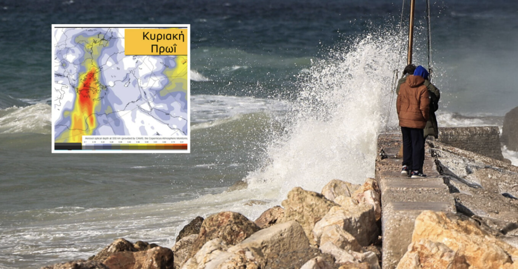
🎯ΝΟΤΙΑΔΕΣ ΚΑΙ ΣΚΟΝΗ ΤΗΝ ΚΥΡΙΑΚΗ
— Theodoros Kolydas (@KolydasT) February 14, 2026
✅Αύριο οι ενισχυμένοι νοτιάδες θα μεταφέρουν μεγάλες ποσότητες αφρικανικής σκόνης προς τη χώρα μας, δημιουργώντας ένα σκηνικό με θολό ορίζοντα, «βαρύ» ουρανό και εντυπωσιακές αποχρώσεις στο ηλιοβασίλεμα.
✅Η συγκέντρωση αιωρούμενων σωματιδίων… pic.twitter.com/c7yC7kSYcj
More specifically:
a. In the Corfu–Paxos area from Saturday evening (14-02-2026) until Sunday morning (15-02-2026)
b. In Epirus from tonight through midday Sunday (15-02-2026)
c. In eastern Macedonia and Thrace on Sunday (15-02-2026) from the late morning hours until late afternoon
- Very strong to gale-force southerly winds will blow tonight in the Ionian Sea (7–8 Beaufort) and on Sunday in the Aegean (8 Beaufort and locally 9 Beaufort in its eastern parts).
- Weather conditions favor a significant transport of African dust to eastern Greece, mainly affecting southern and central regions (Peloponnese, Crete, eastern Central Greece including Attica, the Cyclades and Evia).
Muddy rain, temperatures above 20°C and African dust over the weekend
After the low-pressure systems that affected the country in recent days, the weekend is expected to bring two contrasting weather patterns, with significant regional variations.
Temperatures will exceed 20°C in mainland areas, while Crete may record even higher values, reaching 23°C. However, western and northern parts of the country will experience muddy rain and thunderstorms, with light snowfall in mountainous areas. At the same time, African dust will cover most of the country, with the highest concentrations in southern Greece — especially Crete, the Peloponnese and the southern Aegean. Significant increases are also expected in parts of northern Greece.
Kolydas: Return to calmer conditions with new rainfall episodes
Meteorologist Thodoris Kolydas stated in a post that the atmosphere appears to be returning to calmer conditions, with instability gradually subsiding from Saturday afternoon. However, he warned that the weather will not remain stable for long, as new rainfall episodes are expected on Sunday and Tuesday.
According to his forecasts, Sunday’s rain will mainly affect western and northern Greece, while Tuesday’s system appears more organized and is expected to impact most of the country before gradually weakening and subsiding. Particular attention should be paid to strengthened southerly winds on Sunday, which may reach 8–9 Beaufort in the Aegean.
Temperatures on Sunday will remain high for the season, reaching up to 20°C, while from Tuesday they will drop slightly but remain above normal levels, around 16–17°C.
Tsatrafyllias: Two faces of the weather this weekend
Meteorologist Giorgos Tsatrafyllias emphasized that the weekend will have “two faces.” After recent low-pressure systems, significant regional contrasts are expected.
Western and northern areas will be affected by muddy rain and thunderstorms, with light snowfall in the mountains. In contrast, eastern and southern Greece will see sunshine and high temperatures, exceeding 20°C in mainland areas and reaching 23°C in Crete.
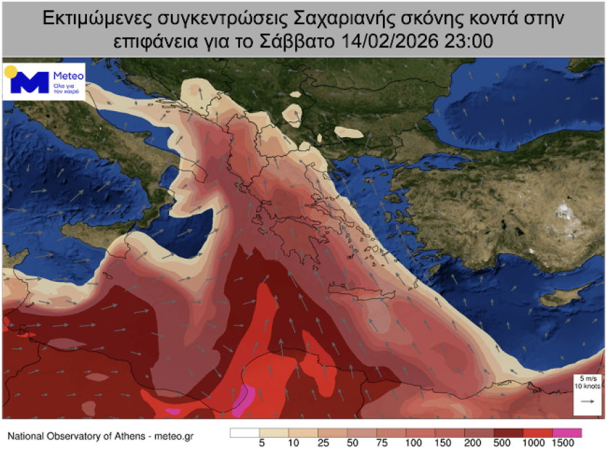
He also noted that Saharan dust will be the common denominator, beginning in western Greece on Saturday and spreading across the country, with the highest concentrations expected in central and southern Greece on Sunday. Winds will be stormy, with southerlies prevailing in the Ionian on Saturday and in the Aegean on Sunday.
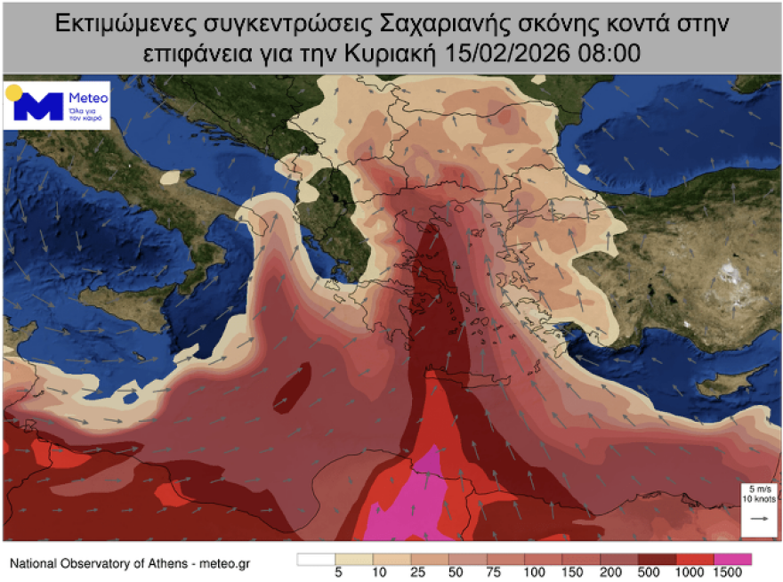
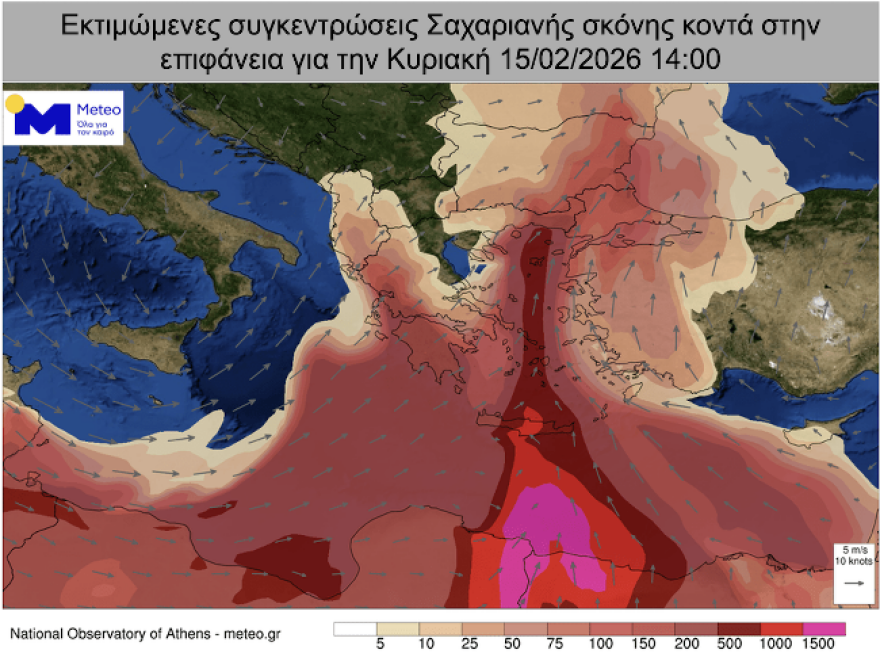
Saharan dust transport and Sunday peak
According to forecast data from the National Observatory of Athens / meteo.gr, Saharan dust transport will affect the country over the weekend, peaking on Sunday, February 15. Dust will cover most of Greece, with the highest concentrations in southern regions — especially Crete, the Peloponnese and the southern Aegean — as well as notable increases in parts of northern Greece.
Today’s weather
Partly cloudy conditions are expected, with increased cloud cover in northern and northwestern Greece. Phenomena will become more widespread in the northwest during the evening. Local thunderstorms may occur in the northern Ionian Sea and parts of Epirus, possibly accompanied by hail.
Temperatures will range:
- Western Macedonia: 0–12°C
- The rest of Macedonia and Thrace: -1–14/15°C
- Thessaly: 2–15/16°C
- Epirus: 1–16°C
- Other mainland areas: 2–17°C
- Ionian Islands: 8–15°C
- Aegean islands and Crete: 8–20/21°C
In the Aegean and Ionian Seas, winds will initially be westerly at 5–6 Beaufort, gradually turning southerly/southeasterly at 6–7 Beaufort and locally up to 8 Beaufort.
In Attica, generally fair weather with temporary cloudiness is expected. Winds will initially be westerly at 3–4 Beaufort, quickly shifting to southerly/southeasterly at 4–5 Beaufort. Temperatures will range from 11 to 18°C.
In Thessaloniki, partly cloudy skies are forecast, with a chance of local rain mainly in the evening. Winds will initially be northwesterly at 2–3 Beaufort, quickly turning southeasterly at 3–4 Beaufort. Temperatures will range from 8 to 15°C.
Weather on Sunday, 15-02-2026
Cloudy conditions with local rain and scattered thunderstorms are expected in western, central and northern Greece, as well as the northern and eastern Aegean islands. In some northeastern areas — and in the west during the morning — phenomena may be intense. Elsewhere, partly cloudy skies with temporary increases are expected. Brief snowfall will occur in central and northern mountainous areas.
Meteorological conditions favor the transport of African dust to central and southern Greece.
Winds will blow in the Ionian from the west-southwest at 4–5 Beaufort and in the Aegean from the south at 7–8 Beaufort, locally reaching 9 Beaufort in the eastern Aegean.
Temperatures will remain high for the season, reaching 18–20°C in most areas and locally 22–23°C in Crete, while in the northwestern mainland they will not exceed 13–15°C.
Ask me anything
Explore related questions